Crandall Arambula report (2002)
1000 Friends of Oregon, Friends of Eugene, Rob Zako, Mary O'Brien, Rob Handy
worse than WEP:
more environmental, financial, community impacts
incompetence or deliberate effort to sabotage the federal legal case against the WEP?
- worse version of WEP
- op-ed about Crandall Arambula
- maps
- details
- no democratic input, "group think"
- ODOT told City IMark Robinowitz was correct
- Roosevelt Extension already rejected
- RG coverage
- Avoidance, then Minimization
- comparison: ODOT, Crandall Arambula, WETLANDS
The "Crandall Arambula" alternative - named for the architecture firm in Portland that drafted it -- was unveiled to the public on September 17, 2002 at a press conference in Bertelsen Nature Park sponsored by Mary O'Brien, Rob Zako and Rob Handy. After public criticism that it would be even worse for the environment than the WEP, it was quietly withdrawn by its sponsors, but no public disclaimer was ever made. Crandall Arambula allowed WEP supporters like Nancy Nathanson and Robert Ackerman to falsely claim that even the environmentalists supposedly recognized a need for an expressway.
In March 2008, the West Eugene Collaborative created by Mary O'Brien, Mayor Kitty Piercy and others welcomed a proposal to consider reviving much of the "Crandall Arambula" proposal, although without the piece of the proposal that included bulldozing the Royal Blue Organics blueberry farm. When asked, the "Collaborators" claimed it was not an official proposal, although why would they waste time and energy floating unofficial ideas that clearly could not be built? Fortunately, the final report from the Collaborators did not include the preliminary idea of the half-a-WEP (twice as illegal), but they did endorse spending more money to widen West 11th than the sum proposed to build the WEP even though a reason the WEP could not be built was "the money was not there."
No one who opposed all of the WEP, specifically anyone who objected to the Crandall Arambula worse version of the WEP was allowed to participate in the so-called Collaborative.
A disclaimer: this report was written by WETLANDS alternative co-author Mark Robinowitz. I had been part of a small group of environmentalists who had been meeting to discuss strategy to stop the WEP, our meetings took place at the 1000 Friends of Oregon Lane County office. In the summer of 2002, Friends of Eugene (which was an active group at that time) convened a legal strategy committee to begin the process of filing a Federal lawsuit to stop the WEP. This committee consisted of myself, Mary O'Brien and Rob Handy.
My participation did not last long, since I wanted to discuss technical details of the project and the many federal laws that prohibited the porkway. O'Brien and Handy, on the other hand, were part of a smaller group (smaller than the group of WEP opponents) who signed onto the Crandall Arambula worse version of the WEP. No amount of rational discussion that federal law would not block a worse option when considering "a range of alternatives" as required by laws such as Section 4(f) could dissuade them from promoting their new route. The idea that we had consensus to oppose the highway, not to redesign it, went unheeded -- and I was quickly expelled from the Friends of Eugene legal committee despite being the sole participant who was familiar with federal transportation laws from previous freeway fights. As of December 2010, Friends of Eugene was still soliciting on its website for the public to contribute money to supposedly help stop the WEP even though the formal "No Build" decision was made by Federal Highway Administration in early 2007.
Dr. John Allcott, a WEP opponent who has a medical practice in Veneta, paid for the Crandall Arambula supporters and opponents to have a professional mediator facilitate discussions within the larger effort of WEP opponents. But despite these discussions, those who worked to promote Crandall Arambula never explained why they excluded the rest of the opponents from their plan for their new, larger highway, and were not able to say why they did not even bother to look at a map to see what they were proposing to pave before holding a press conference promoting their proposal.
It was interesting karmic justice that their final route proposal, unveiled at their press conference, would have gone through the Royal Blue Organic Blueberry Farm (Mary O'Brien once worked for NCAP, the executive director's husband owned that farm) and the property of an individual that 1000 Friends and Friends of Eugene had co-filed an appeal of the WEP related land use actions before the State of Oregon's Land Use Board of Appeals. If one had made up this scenario it would seem too absurd to be true. As predicted, the LUBA appeal failed, not because of this silly new route proposal but because the State's land use laws are much weaker than the rhetoric surrounding them. Only the Federal laws and regulations still had power to stop the porkway - and that is why the WEP was not built.
| What was the Crandall Arambula report? |
On Tuesday, September17, 2002, a press conference was held near Stewart Pond in west Eugene by Crandall and Arambula, a Portland based architect firm that promotes transit-oriented development as its specialty, sponsored by local activists Mary O'Brien, Rob Handy and Rob Zako . This report had been promoted in the media several times over the summer as an expert opinion that would show how the WEP need not be built.
However, this report was a new way to build the WEP that would increase the cost, environmental destruction, and community impacts of the project even beyond the plans that ODOT has. This new version would even be more illegal than ODOT's version of the WEP, itself one of the most illegal highways ever proposed in the US.
THE NEW WEP ROUTE PROPOSED BY CRANDALL AND ARAMBULA WOULD THREATEN THE ROYAL BLUE ORGANICS BLUEBERRY FARM (on Royal just west of Green Hill). It is possible that this could be shifted more to the south and go next to the farm, but this would risk taking more homes. Either way, this would require exceptions to Oregon State Planning Goals 3 (farmland), Goal 4 (forest - there's old oak forest on Oak Hill to clearcut), Goal 14 (urbanization - the new route would have a LONGER path outside the Urban Growth Boundary than the WEP to Goble Lane) and several other goals. These are some of the legal issues that 1000 Friends of Oregon and Friends of Eugene are appealing the local land use changes (to permit the WEP) that were passed by Eugene, Springfield, Lane County and Lane Transit District in July.
The new WEP route would pave over MORE acreage of Willamette Valley native wet prairie than the route proposed by ODOT.
Examination of a detailed map of the Lower Amazon Restoration project shows that Crandall's Parkway would pave about one third more Willamette Valley wet prairie than ODOT is planning. Wet prairie is an ecosystem that only has about 0.1% remaining. This figure discusses the area between Terry Street and Green Hill Road (the only area that the report considered to have important habitat worth protecting - even though it recommended greater direct impact on the wetlands). Both the ODOT and the Crandall Parkways would pave over prairie near Terry Street, but this is not calculated.
If the Crandall Parkway is to avoid the Pacific Industrial Park, it would require a swooping curve that would come close to, if not actually pave over, the remnant patch of TIMWORT (highly rare plant) that was found by a citizen activist / botanist in spring 2002.
In summary, the C&A alternative is a "straw man" alternative that makes ODOT's WEP alternative look more reasonable in comparison. If the authors of this report were trying to scuttle a federal legal challenge based on failure to consider alternatives, then they were successful, since offering an alternative with greater impacts does not force reconsideration or cancellation of the ODOT preferred alternative.
The WETLANDS alternative, on the other hand, is evidence that a "prudent and feasible" alternative exists that prevents the need for destroying critical habitats, wetlands and wildlife refuges. The WETLANDS alternative should be given complete analysis in a new Draft EIS, should the project not be canceled altogether. (Most of the WETLANDS alternative would not require an EIS - a more modest Environmental Assessment and Finding of No Significant Impact would be sufficient to approve this reasonable alternative.)
The Eugene Weekly's coverage is at www.eugeneweekly.com/archive/09_19_02/news.html#news1 and a rebuttal by Mark Robinowitz (Reasonable Alternatives: We Can Do Better than WEP or Crandall Arambula) is at www.eugeneweekly.com/archive/09_26_02/views.html#viewpoint1
Eugene Weekly, September 26, 2002
Viewpoint
By Mark Robinowitz
Reasonable Alternatives
We can do better than WEP or Crandall Arambula.
Last week's article "Fork in the Freeway" discussed an approach to the West Eugene Parkway (WEP) that claimed to be "wetland friendly." However, the proposed new route would pave more acres of protected wetlands, cut more forests, cost more and threaten the Royal Blue Organics blueberry farm on Royal Avenue.
The original idea for this report from Portland architects Crandall Arambula (CA) was to draft an alternative similar to the Land Use, Transportation, Air Quality (LUTRAQ) study in Portland. LUTRAQ substituted a new rail line, transit-oriented zoning and modest work on existing roads instead of a giant Western Bypass from Wilsonville to Vancouver. Instead, the report developed an "alternative route" that would cause more environmental and community havoc than even the plans ODOT is finalizing, which makes the official plans look more reasonable.
During consideration of alternatives, highway departments often propose deliberately worse options in order to make the preferred route seem acceptable in comparison. In this case, the WEP would build six miles of new expressway (not including the future extension to Veneta). The CA report recommends 10-1/2 miles of new expressway, although some of that would only be for buses. At CA's presentation to the Eugene Planning Commission, Eugene highway planner Dave Reinhard remarked that the report's recommendation of bus-only roads (between Danebo Road and 99) should be built for all traffic modes.
The report also included a bus-only expressway for three miles outside the Urban Growth Boundary (through farmland) along Green Hill Road to the Eugene Airport.
If built, this new road would faciliate the UGB expansion into farmland, and after converted to mixed use (cars and buses) would likely be the first leg in a Eugene "Outer Beltline" through Santa Clara and ultimately to I-5 at Coburg. (The Lane Council of Governments "2050" report proposes expansion of the Eugene UGB to Junction City and Coburg, and to Coburg and Pleasant Hill to the south.)
On Sept. 21, The Register-Guard ran an article about CA's $30,000 contract with the city of Springfield to help design the pedestrian-oriented villages that will be constructed as part of the PeaceHealth hospital. Some of these new subdivisions would be in the McKenzie River floodplain, and are unlikely to mitigate the traffic impact of relocating this major facility from downtown Eugene.
Over the next few months, a new project titled WETLANDS (West Eugene Transportation, Land and Neighborhood Design Solutions) will develop a sensible alternative to the WEP that would not pave parklands or disrupt existing communities, would address traffic bottlenecks and poor road designs, and cost less.
An outline for the WETLANDS alternative was suggested in June 2001. At that time, prospects for the WEP looked bad, and ODOT suggested widening West 11th west of Beltline, and Beltline itself, to address the state's concerns about through traffic. Shortly afterwards, on July 25, Councilor Pat Farr said that an obvious alternative to the WEP would route traffic from West 11th to Beltline to Roosevelt to Highway 99. Roosevelt near Beltline is already close to expressway standards and is not crowded during rush hour. Using this existing road instead of building the WEP would require upgrades to key intersections of 11th, Beltline, Roosevelt and 99. The WETLANDS alternative proposes shifting the $17 million already allocated for the WEP's first phase toward this construction and for added shoulders on West 11th/Highway 126 from west Eugene to Veneta. (The full WEP cost, officially estimated at $88 million, would exceed $150 million when the full Veneta to I-105 route is considered.)
The most important parts of an alternative would be fixing the existing problems on West 11th and shifting the zoning to support an integrated approach to transportation and land use. Much of the problem with the West 11th strip malls was caused by haphazard planning that placed too many driveways along the road, which reduces the traffic capacity and increases the potential for accidents. The city is required to spend at least $2.2 million to extend Terry Street to the WEP for the highway to function properly — this money would go a long way toward consolidating driveways, adding turn lanes at congested intersections, making the area less hostile to pedestrians, and other, relatively cheap solutions.
In addition, Eugene could pass a moratorium on new Wal-Mart type big-box franchise stores that damage the local economy (this has been done in many other communities).
The parking lot behind Fred Meyer is planned for yet another out-of-state chain store. If the zoning was changed to residential, this lot could be used to establish a neighborhood node that encourages residents to walk to shopping and jobs and would be served by the Seneca transit station (which may be upgraded to Bus Rapid Transit in the future). Intelligent re-use of abandoned parking lots is preferable to paving wetlands.
At 1 pm Sunday, Oct. 13, at Wallis and Fifth Avenue, WETLANDS and the Green Party will lead a tour through forested wetlands on the WEP route between Bertelsen and Seneca roads.
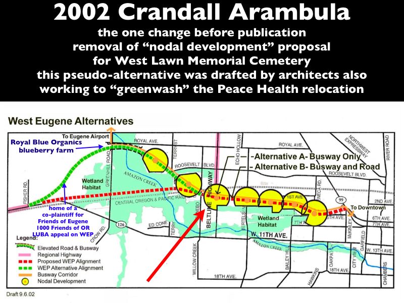
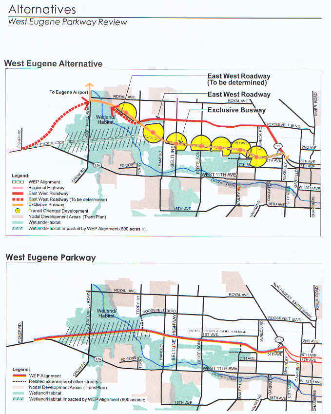
| Map of Crandall Arambula worse WEP version |
note: these maps, provided by Crandall & Arambula, are not completely accurate. The WEP (official route) would go through the wetland habitat east of Beltline in Bertelsen Nature Park (this map claims it would not). Much of the indirect impact of habitat fragmentation would also happen east of Beltline. Building a two lane highway for buses (eventually expanded to buses plus a road for cars and trucks) through the wetlands and forest would be virtually the same as the WEP itself -- and of course it would be a highway PLUS a busway (no one seriously believes that the WEP would only be built for buses to new shopping districts in the middle of the wetlands). Calling it something other than WEP is disingenuous.
www.registerguard.com/news/2002/09/18/images/parkwayaltmap.jpg -- for map of new route proposed for West Eugene Porkway by Crandall-Arambula (one that is not detailed nor completely accurate).
This is an alternative route to part of the WEP with most of it still being built plus new devastation not planned by ODOT. This was NOT an alternative to building the WEP, but a straw man option that was worse than the WEP.
This new WEP route would slice up forested wetlands east of Beltline, pave over critical habitat / Willamette Valley native wet prairie west of Beltline (more acreage of direct impact than proposed by ODOT), go through or next to the Royal Blue Organics blueberry farm (on Royal), pave farmland outside the Urban Growth Boundary to build an expressway for buses along Green Hill Road to the Eugene Airport, and gouge a deep road cut through Oak Hill, west of Green Hill Road. On the positive side, this road cut would finally solve the problem of where to get the sand and gravel for the WEP's construction through the West Eugene Wetlands.
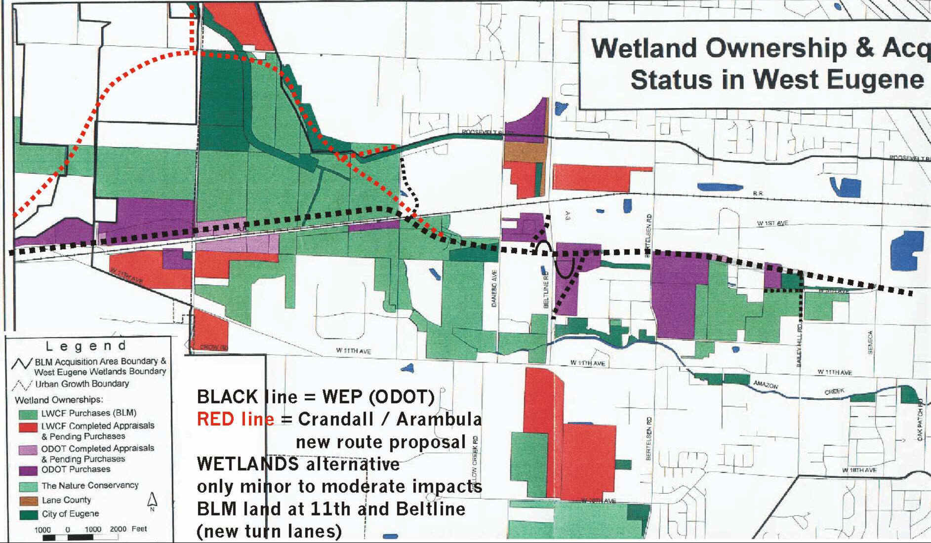
Scanned in map of "Wetland Ownership and Acquisition Status in West Eugene Area," produced by Lane Council of Governments, June 2001.
The dashed lines represent the route(s) of the so-called Parkway to indicate which public lands would be destroyed by each proposal.
If the Beltline / West 11th intersection is significantly widened for the WETLANDS alterantive (or even as part of the WEP), the edge of some LWCF property would need to be condemned. However, if this was done instead of the WEP (and the rest of the WEP was genuinely canceled by converting the ODOT property to BLM conservation areas), this would meet the legal requirements for "avoidance, then minimization" that apply to wetland destruction permits (section 404 of the Clean Water Act) and protection of parklands and publicly owned wildlife refuges (section 4(f) of the 1966 Transportation Act).
Note: the exact route of the new proposal for the WEP from Crandall and Arambula was never precisely defined, but this is an educated guess about where the route would probably go.
C&A new route through Oak Hill (some of this land is designated "urban
reserve" to be included in the Eugene Urban Growth Boundary after the highway is
built)
The WEP would parallel the railroad tracks east of the point where 126 crosses the tracks.
LWCF is the Land and Water Conservation Fund, a federal source of money for purchasing endangered habitats. LWCF land is not to be used for highway construction, it is solely bought for conservation.
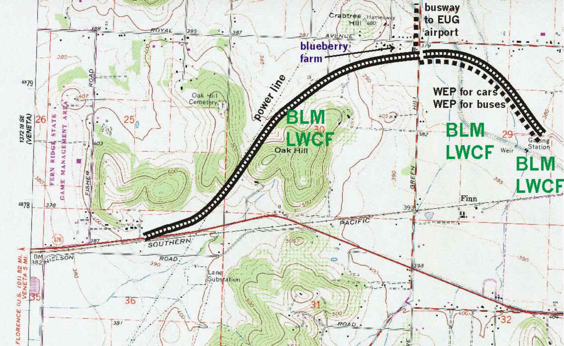
Crandall - Arambula is an architecture firm in downtown Portland (www.ca-city.com is their website)
In the summer of 2002, a group of WEP opponents approached a Portland architecture firm to help flesh out suggestions for the WEP alternative. This good intention quickly morphed into a political disaster for WEP opponents. While the principle in this firm had ties to 1000 Friends of Oregon, the firm was also working for real estate speculator John Musumeci on his plan to relocate Sacred Heart hospital to the McKenzie River floodplain (something that was kept secret from the WEP opponents).
Despite several quality briefings, the firm (Crandall Arambula) chose to ignore the stated position of the group of opponents, and developed a series of different designs for a new option for the WEP. They had been tasked to help illustrate an alternative TO the highway, not an alternative route of the highway. The first round suggested a "half WEP" option that had already been rejected through the Environmental Impact Statement process as twice as illegal (federal law prohibits this sort of "segmentation" of approving roads). A subsequent redesign crafted a WEP route with nearly twice as much mileage as the option that ODOT was promoting. It is hard to believe, but this new option would have had more ecological and social impacts that the version "we" were supposedly trying to stop. (This new option would have paved over more acres of wetlands, cost more, clearcut more forests and would have gone through the Royal Blue Organic blueberry farm.)
The reason to cite all of this history is that the WEP opponents who opposed this disaster were shut out of this process. The one input that we were allowed to have was to point out that the Crandall Arambula team had proposed replacing a cemetery with a commercial shopping "development" -- that proposal was quietly removed just before publication, which is proof of their incompetence and refusal to look at any maps of the area to see what was in the path of their proposal. If the promoters of the WEP had tried to create an "alternative" to the WEP that was deliberately designed to undermine the pro-environment side in federal court, they would not have been able to craft a version worse than the Crandall Arambula option.
At least our split on the West Eugene Parkway happened before we got to federal court, since if the "Crandall Arambula" proposal had been adopted by the plaintiffs (the environmentalists) while sueing the Federal Highway Administration, an attorney would have to stop their representation since the positions of Mary O'Brien, Rob Zako and Rob Handy in promoting the worse WEP version "Crandall Arambula" were completely incompatible with the opposition to building any part of the WEP that many of the other WEP opponents had.
"Groupthink is a type of thought exhibited by group members who try to minimize conflict and reach consensus without critically testing, analyzing, and evaluating ideas. During groupthink, members of the group avoid promoting viewpoints outside the comfort zone of consensus thinking. A variety of motives for this may exist such as a desire to avoid being seen as foolish, or a desire to avoid embarrassing or angering other members of the group. Groupthink may cause groups to make hasty, irrational decisions, where individual doubts are set aside, for fear of upsetting the group’s balance. The term is frequently used pejoratively, with hindsight."
http://en.wikipedia.org/wiki/Groupthink
"no matter how cynical you get, it's hard to keep up"
-- Lily Tomlin
| Poor decisions caused by anti-WEP group's lack of democracy and "groupthink" |
Fortunately this disaster did not happen while the environmentalists were filing a federal lawsuit. It showed who was willing to compromise and who was not, who was going to stick to principles and who could be swayed by rhetoric that was not matched by facts.
If this alleged alternative was used in a federal court to challenge the WEP, this proposal would negate most of the federal legal objections to the WEP.
Crandall Arambula made "sense" if you wanted to build a new highway and thought that only one spot in west Eugene deserved protection. However, most of the route has unique natural features that are worthy of conservation, and the alternative consensed upon at the June 2001 West Eugene Charette (which Rob Zako was at) is a much better place to start an alternatives discussion. Furthermore, the poor quality of the C&A report led to absurdities such as proposing to shift the highway through the Royal Blue Organics blueberry farm (owned by a friend of one of the promoters of C&A) and the private home of a citizen who was a co-plaintiff with Friends of Eugene on the State Land Use Board of Appeals (LUBA) challenge of the 2002 TransPlan amendments. If one made up this sort of thing it would be hard to believe -- and the ODOT officials privately expressed amazement that this was actually seriously proposed. (Proposing a parkway through your co-plaintiff's home is not a good way to maintain plaintiff solidarity.) A draft of the C&A even proposed converting a cemetary into a mixed-use commercial development as part of a land use shift to build dense transit-only development around proposed bus stops in the wetlands, which is proof that the consultants and their supporters did not bother to consult a map and were not familiar with the area that they were redesigning.
| new bike path a caution for naive environmentalists |
The bike path crossings of Amazon tributaries resemble highway bridges, not bike paths. (These are not bike path bridges - they are reinforced concrete that look like they could tolerate the weight of triple trailer trucks.) It is complete overkill even for having to cope with the weight of emergency ambulances in case someone is injured while bicycling. This is a cautionary tale for giving the highway people permission to build something modest - by the time they are doing their work, the full impact is often greater than anticipated.
ODOT's analysis of Crandall Arambula:
they were surprised that "environmentalists"
offered a more destructive plan than their proposal
October 3, 2002
Mayor James Torrey
City of Eugene
777 Pearl Street, Rm 105
Eugene Oregon 97401
Subject: Crandall Arambula Alternative to the West Eugene Parkway
Dear Mayor Torrey:
As you know, ODOT is always willing to listen to suggestions for improving the
transportation system. ODOT is pleased that the highly acclaimed urban design
firm of Crandall Arambula donated their time to offer suggestions for improving
transportation in west Eugene. Because the presentation of the Crandall Arambula
Alternative (C/A Alternative) received wide exposure, we thought you and the
public would appreciate learning of ODOT’s initial response to the C/A
Alternative.
The C/A Alternative has three major elements: 1) Using Roosevelt Boulevard as the east-west expressway for vehicles. 2) Nodal development that emphasizes high-density Transit Oriented Development around the BRT stations. And 3) An exclusive bus lane for Bus Rapid Transit (BRT) that would use the eastern portion of the WEP alignment.
We appreciate the recognition of the need for an east-west expressway for freight and automobile traffic. The best location for a west Eugene expressway has been debated for decades. The Roosevelt Freeway concept was abandoned in the 1970’s because of the impacts to the Bethel and Whitaker neighborhoods. Changing Roosevelt to a state highway would have significant adverse impacts on the local community. Changing the zoning of hundreds of acres from industrial to Transit Oriented Development (TOD) may have severe impacts on industrial development in Lane County.
One reason Crandall and Arambula suggested using Roosevelt for a state highway is to reduce environmental impacts. While their alternative is not detailed enough to provide precise estimates of impacts, a review of the their alternative indicates that the impacts on the environment are likely to be greater than those anticipated with the construction of the WEP. Even the ever-vigilant Mark Robinowitz says the C/A Alternative would pave more wetlands and cut more forests than the West Eugene Parkway. The following is our initial assessment of the impacts of the C/A Alternative:
C/A Alternative BRT Route
Stephano Vigiiano, Lane Transit
District Director of Development Services, says that the BRT system is intended
to replace existing service on existing corridors. That results in a net reduction
in operating expense because the BRT service is more efficient (in travel time)
than conventional bus service. It also guarantees a market for BRT, since it
runs through established development. The C/A study would add BRT to an area
that doesn't have transit service. West Eugene would still need to provide service
on West 11th and Hwy 99. Thus it would greatly increase operating cost by adding
a new route through largely undeveloped property. LTD would have a very difficult
time financing the new route to the airport.
BRT lanes from Garfield to Terry Street Between Garfield and Terry Street, the C/A Alternative proposes an exclusive bus way that would closely follow the alignment of the proposed West Eugene Parkway. The impacts of the bus way and associated infrastructure would have about the same impact on wetlands and natural areas as the expressway it would replace. The proposal for five stations with TOD along this route is likely to cause additional environmental impacts.
New BRT lanes from Terry Street to the Airport West of Terry Street, the BRT lanes would run through the planned Royal Avenue nodal development and then along Greenhill to the airport. The line along Greenhill would impact several miles of wetlands to get to the airport.
Roosevelt Boulevard Using Roosevelt Boulevard as a state highway to connect Highway 99 to Highway 126 west of Greenhill Road has been examined several times over the last 30 years. Each time this alternative was rejected. Hundreds of families have moved into the neighborhoods that border Roosevelt with the understanding that Roosevelt would remain a local arterial.
Hwy 99 to Terry Street Making Roosevelt Boulevard an expressway from Hwy 99 to Terry Street would impact the A-3 Channel and its associated wetlands and/or the adjacent neighborhoods. Since open channels are protected in Eugene, the impacts to the neighborhood would be significant. A second serious impact would be the required upgrade of the Hwy 99/Roosevelt intersection and the Roosevelt/Chambers Street intersection. Bridges and ramps would be required, with potential serious impacts to businesses, residents, and the economic viability of the Four Corners area. There would be high-cost mitigation required for decontamination and hazardous cleanup that could be located around both intersections.
Terry Street to Greenhill Road We assume the C/A Alternative would have BRT lanes run through the neighborhood to serve nodal development or TOD. The expressway would then need to run west of the new Fern Ridge Bike Path to avoid significant impacts on the Royal Avenue Community. This would route the expressway cross the wetlands and mitigation banks in the West Eugene Wetlands for about a mile with crossings of Amazon Creek and diversion channel.
Greenhill Road to Fisher Road If the proposed expressway is routed east of Oak Hill, it would run across wetlands and wetland mitigation sites from Greenhill Road to its connection to Hwy 126. If the expressway is routed over Oak Hill, it would impact wetlands and Oregon white oak forests. According to the Oregon Biodiversity Project, Oregon white oak woodlands provide some of the ecoregions’s most important wildlife habitat. If the expressway is routed west of Oak Hill, it would impact wetlands, farmed wetlands, and oak woodlands. If the route goes west very far, it could hit the Fern Ridge Wildlife Refuge. The attached soils map has hydric (wetland) soils highlighted. The shortest distance between two points is a straight line. The WEP provides the shortest route between Danebo and Hwy 126. The broad arc proposed by Crandall-Arambula would inevitably impact more acres.
The development of the BRT System is being done in segments with designs addressing specific local issues. LTD has not had the time to examine the West Eugene BRT routes in detail. TOD may play a role along some of the routes but these will raise many land use issues. ODOT and LTD will be working together as ODOT completes the designs for the West Eugene Parkway to provide the best transportation system we can afford with the least adverse impacts.
ODOT staff will be meeting with George Crandall and Don Arambula to discuss the transportation system in west Eugene. Because the alternative they presented would result in unacceptable adverse impacts, we will not prepare a Supplemental Draft Environmental Impact Statement to examine this alternative in detail. We do not intend to detour the environmental process, we continue to follow the schedule for the West Eugene Parkway that we sent to you previously.
Yours truly,
Robert Pirrie
Area Manager
| Roosevelt EXTENSION Alternative has already been rejected -- the solution is to efficiently use existing Roosevelt and fix the Roosevelt intersections at Beltline, Hwy 99, no need to build a new expressway across wetlands, forests and farms |
"Roosevelt Extension Alternative This alternative would include widening Roosevelt Boulevard between Highway 99 and its current terminus, and extending it southwest across open space areas to the proposed WEP terminus. It would require interchanges at Roosevelt Boulevard / Highway 99, and Roosevelt Boulevard / Beltline Highway, and substantial intersections at Terry Street and Green Hill Road. This alternative would be unreasonable because it would result in unacceptable impacts to valuable wetland and upland habitat areas, including crossing over approximately 914 linear meters of wetlands classified in the West Eugene Wetlands Plan (WEWP, 1992) as "Wetlands to be Protected," "Wetlands to be enhanced for Mitigation Credit," or "Upland Mitigation Sites." Additionally, widening to accommodate parkway needs would result in unacceptable impacts to intensive residential land uses and neighborhood identity / cohesion.
-- Supplemental Draft Environmental Impact Statement (1997), p. 2-20
[ODOT's preferred alternative would also have these impacts.]
http://www.ci.eugene.or.us/wewetlands/WEWP2000/WEWP2000_Appendices.htm
[note: no longer at that address]APPENDIX F
TransPlan Projects Removed
The following TransPlan projects are no longer planned to be constructed and are therefore not eligible for the Planned Transportation Corridor designation
#150 Extension of Beltline Road from W. 11th to W. 18th
#162 Extension of Terry Street from W. 11th to West Eugene Parkway
#228 Extension of Roosevelt Boulevard from Terry St. to Greenhill Road
The Supplemental Final EIS will probably have an addendum to this statement that the Crandall / Arambula Alternative is unreasonable due even longer linear impact to wetlands and upland habitats, farmland, violations of the WEWP and increased costs. An alternative that has the same problems as the original proposal does not meet the "avoidance" requirements of Section 4(f) of the Transportation Act and Section 404 of the Clean Water Act, nor does it meet the requirements for supplementing an EIS (or starting a new EIS) at 23 CFR 771 (FHWA regs) or 40 CFR 1500 (Council on Environmental Quality regs on NEPA).
| Register-Guard coverage, with rebuttals |
www.registerguard.com/news/2002/09/18/1a.noparkway.0918.html
September 18, 2002
Design firm suggests parkway alternative
By JOE MOSLEY The Register-Guard
A Portland urban design firm presented its study of alternatives to the West Eugene Parkway on Tuesday, recommending the widening and extension of Roosevelt Boulevard in place of the throughway.
The company also called for development of a dedicated Bus Rapid Transit route along a portion of the abandoned parkway's right-of-way.
[this would cause the same amount of damage to forested wetlands east of Beltline, since it would BE the WEP, but merely for buses - although future expansion to include cars would be likely. Since the buses would drop passengers off in the middle of wetlands and forests and low-density industrial areas, the proposal includes conversion of industrial lands to high density, gentrified commercial and residential "transit oriented development." The report completely ignored potential to fix problems with existing commercial areas and traffic problems along West 11th Avenue.]
"I have to emphasize this is one alternative," said independent planner George Crandall. "There are other alternatives, but we feel this is the most promising."
[ODOT has already rejected the proposed extension of Roosevelt Blvd due to its wetland destruction. But even ODOT never proposed slicing through Oak Hill nor threatened the Royal Blue Organics farm on Royal Ave]
His firm, Crandall Arambula PC, produced the report free of charge to avoid the appearance of bias after being approached earlier this year by local activists who have fought the parkway's development.
Crandall and his partner, Don Arambula, gave their presentation first in a news conference organized by parkway opponents at the site of wetlands threatened by the parkway, and then in more detail at a special meeting of the Eugene Planning Commission.
The design team - which has been involved in the planning of light rail routes in the Portland area - maintained that the alternative to the parkway would provide comparable automobile access from Eugene's western edge to the city's downtown. But it would open far greater opportunities for a workable mass transit line and associated "transit-oriented developments" at BRT stops, and would have only a fraction of the impact on wetlands.
[a careful review of the wetland maps prepared by the West Eugene Wetlands Project shows that Crandall's new route would have about one third more direct impact on wetlands between Terry Street and Green Hill Roads, more impact than ODOT's plans between Terry and Beltline, and would be the exact same impact as WEP between Beltline and Highway 99. The new route would also clearcut oak forest on Oak Hill that was bought by the BLM to provide a wildlife corridor between the West Eugene Wetlands and Fern Ridge.]
Crandall said the parkway would have a negative effect on as much as 600 acres of wetlands, while the alternative extension of Roosevelt would cross less than a quarter-mile of the wetlands at its northern end. The impact could be lessened further by opting for a raised roadway through the area.
[The alternative extension would pave a mile of wetlands just between Terry and Green Hill Roads, not a quarter mile. Building an elevated road like the Washington-Jefferson bridge through endangered species critical habitat would not solve any environmental concerns. It fails the legal requirements that AVOIDANCE of wetlands, parklands and endangered species habitat must be considered before MINIMIZATION and MITIGATION.]
"You have this wonderful resource, and it shouldn't be compromised, in any way," he said.
Mark Wigg, the Oregon Department of Transportation's environmental project manager for the parkway, said the new study is worth considering. However, he stopped short of endorsing Crandall's call for a new environmental impact statement to compare the two transportation proposals.
"We just have to run some numbers," Wigg said. "There's a reason for the West Eugene Parkway. But we do look at alternatives as they come in."
Reaction of city officials was mixed.
City Councilor David Kelly liked the idea of a westside traffic connector with minimized damage to wetlands and said the suggestion about mass transit opportunities "is very, very well-taken." Kelly ardently opposed planning amendments enabling the parkway project to proceed when the council passed them on a split vote two months ago.
But Councilor Pat Farr, a parkway supporter whose ward includes much of the area involved in both plans, pointed out that Roosevelt Boulevard is now designated as a residential feeder street rather than a state highway. Changing Roosevelt's designation would most likely not be welcomed by residents bordering it on the west side of Highway 99, he said.
[at a July 25, 2001 City Council forum, Farr admitted that using Roosevelt would make sense if the WEP is not built. But this would be routing traffic from 126 to Beltline, up Beltline to Roosevelt, and then down 99 to downtown. A sensible alternative would include utilizing existing segments of Roosevelt between Beltline and 99, which already is at near expressway design standards. This would NOT involve extending Roosevelt through critical habitats.]
"I think we've done everything we can to answer the (parkway) questions, and it's time to move forward," Farr said. "I'm not adverse to better solutions, but I just don't know that running Roosevelt through residential neighborhoods as a state highway is a better solution."
Reaction also was mixed from residents in the area.
Paula Carson said she has been trying to sell her house at the corner of Maple Street and Roosevelt Boulevard.
"A lot of feedback I get is this is a lousy location because there's just too much traffic," Carson said. "They need to buy us out or put up a wall. I'm against turning this into a highway because people live along it. I'd like to see the Portland planners try to sleep the night here or sell a home here."
Autumn Sanders has lived on Duke Snider Avenue, which is accessed by Maple for nearly five years. She thinks a wall is a bad idea, but not necessarily a freeway.
"It's pretty much a freeway as it is," Sanders said. "I mean it already sounds like a freeway so it wouldn't matter."
"A freeway would be too much noise," said Edy Herrara, who moved with his family to the neighborhood from Los Angeles.
"We came from the big city and we lived for 20 years with the L.A. freeway in our front yard. So I'm crazy from freeways," he said with a laugh.
Both city councilors agreed that the issue is beyond the city's control and any changes to the parkway plan are now up to the state Transportation Department and the federal Bureau of Land Management, which has authority over area wetlands.
"I think the state would be willing to listen to local input, but our local input has vacillated so much over the past several years, I don't know if it would have any credibility," Farr said.
He suggested that councilors consider the new study independently, then schedule a discussion "if there's any energy" to do so.
The state Transportation Department already has allocated $17.3 million for the $88.5 million project's first phase.
[the full cost of the WEP would exceed $150 million - including inflation, the $17 million Beltline / WEP interchange, other local road projects needed for WEP, the WEP extension along 126 to Veneta ($13.319 million according to Lane County) and unspecified extension along 6th & 7th Avenues to I-105]
[the $17.3 million would be better spent on widening the intersections at Beltline / 11, Beltline / Roosevelt, Roosevelt / 99, and extending a shoulder along 126 from Terry Street to Veneta. If there's money left over, it could be spent on safety projects on 126 between Veneta and Florence - turn lanes, climbing lanes]
Wigg, the project manager, said Tuesday that it would be difficult but "not impossible" to use the allocated money instead on a Roosevelt Boulevard widening and extension project. However, he said the city street would first have to be made a state highway - which would require alterations to local and state transportation plans.
[The Nov. 2000 West Eugene Wetlands Plan already removed a previously planned extension of Roosevelt, which makes this proposal impossible unless the WEWP is abolished. The WEWP also prohibits any road projects through the wetlands that was not included in the 1986 version of TransPlan - so this would be another obstacle to the Crandall Parkway. The new route also would pave wetlands designated as "protect" and "restore" in the WEWP, which makes further consideration of this bizarre plan unlikely. Indeed, it would disrupt the multi-million dollar 11-35 project, a joint Army Corps of Engineers / BLM / City of Eugene effort that has been restoring some of the historic floodplain of Amazon Creek, since the new route would likely require considerable filling in of recently restored floodplains.]
Crandall called his firm's proposal "conceptual" and said details - including costs - are yet to be worked out. But he said it would presumably be less expensive than the parkway proposal, because it involves less road-building.
[Actually, Crandall's suggestions involve considerably MORE road building - more mileage, a more complex design (the proposed quarter mile long bridge over Amazon Creek would be very costly). Crandall also suggested building a three mile long bus-only expressway along Green Hill Road from Royal to the Eugene Airport, which would be expensive and pave farmland outside the Urban Growth Boundary. This is a violation of the UGB that ODOT has not proposed for the WEP, it would be in addition to the puncturing of the boundary on the westside. Perhaps from the perspective of a downtown Portland office building, a dedicated transitway to the airport seems sensible - since PDX is a busy airport. But EUG is much smaller - and a shuttlebus to downtown that merely drove on existing lanes on 99 would probably be adequate.].
At the planning commission meeting, Commissioner Art Farley called the Crandall Arambula concept "visionary," but he suggested that it may take as long as 50 years to fully develop.
"I think within the next five or six years, you'd see substantial movement toward it," Crandall said. "There'd be movement toward what you have in mind."
His proposal envisions a total of seven "transit-oriented developments" along the Bus Rapid Transit line, each centered around a transit station and small commercial district, with high- and medium-density housing extending in concentric rings about a quarter-mile in radius from the hub.
[The Sept 6 draft of this report included the West Lawn Memorial Cemetary as a location for transit-oriented development, which suggests that maps were not consulted for this report. Another "T.O.D." would be in the tree farm behind the Weyerhauser plywood mill on Danebo, which emits cancer causing pollution - not a good place for a gentrification urban development project. Other new developments would result in deforestation along the A-3 tributary of Amazon Creek, already the most polluted waterway in the City - our creeks need forested buffers, not new expressways.]
[It is hard to imagine a plan that would construct 2/3rds of the WEP only for high speed buses. Eugene highway planner Dave Reinhard asked Crandall at the Planning Commision if it wouldn't make more sense to build a road for cars next to the road for buses (on the eastern segments of the WEP. Crandall replied that it had been thought about, and should be given further consideration.]
Bottom line: we get a WEP for cars AND a WEP for buses, more impacts on wetlands, our wallets, our parklands, farms, forests and the urban growth boundaries.]
The regional transportation plan now calls for a BRT line to run out West 11th Avenue, but city officials have acknowledged that approach may be a problem because the roadway already is overcrowded.
Planning Commissioner John Belcher also was reluctant to embrace the Crandall Arambula proposal, citing transportation and zoning issues that would have to be resolved for it to be a viable alternative to the parkway.
"But should the West Eugene Parkway not make it through all the hoops, this looks like a good place to look next," Belcher said.
Register-Guard reporter Garret Jaros contributed to this report.
Copyright © 2002 The Register-Guard
posted under guidelines of "Fair Use" doctrine for non-commercial purposes
Avoidance,
then Minimization: 4(f) and LWCF impacts |
|
| Avoidance WETLANDS alternative, option 1 |
No Build for WEP, finish Beltline Phase 3, widen West
11th west of Beltline, improve land use, fix existing intersections, Bus
Rapid Transit to Bethel turn lanes at West 11th / Beltline may or may not fit into current right-of-way (if not, then minor 4(f) / LWCF impacts) |
| Minimization WETLANDS alternative, option 2 |
All of the above except grade-separated interchange at West 11th / Beltline intersection (or intersection resembling 126 at Main Street in Springfield). ODOT recommended "No Build" for WEP, widen Beltline and widen West 11th, plus a West 11th / Beltline interchange at June 2001 "West Eugene Charette." |
| No avoidance, minor minimization | WEP with design changes to reduce footprint vs. "Modified Project" (retaining walls and/or elevated highway on pylons). The 1997 route would be twice as wide through the BLM lands as the 1990 route, requiring more acres of wetland destruction, 4(f) impacts and LWCF land transfers. This would be more expensive than the WEP route proposed in 1997 and informally selected in 2000. |
| No avoidance, no minimization | WEP Modified Project in Supplemental Draft Environmental Statement (1997) and upcoming Supplemental Final EIS (2006?) |
| No avoidance, no minimization, failure to disclose all impacts | WEP Modified Project plus tributary road projects (stated and unstated), mitigation for congestion (wider intersections and possible future grade separations), WEP extended west along 126 to Veneta |
| Compensatory mitigation | not possible, because there are no other large, contiguous wetland prairies to acquire and protect along Amazon Creek in the West Eugene Wetlands |
| Greater damage than ODOT plans | Crandall - Arambula new route has greater direct impacts on wetlands, forests, neighborhoods, transportation budgets and public lands bought with LWCF funds that are subject to Section 4(f) of the Transportation Act. |
| Comparison of Alternatives: ODOT, Crandall Arambula, WETLANDS |
Comparison of Alternatives
1. ODOT West Eugene Parkway (WEP)
2. Crandall / Arambula "Alternative" (C&A)
3. West Eugene Transportation, Land and Neighborhood Design Solutions (WETLANDS)
WEP - The West Eugene Porkway as proposed by ODOT and Federal Highway Administration (FHWA).
C&A - the "alternative route" for the WEP as unveiled by Crandall and Arambula (Portland based architecture firm) on September 17, 2002. This would construct most of the WEP, but only for high speed buses. A new expressway would extend through the wetlands from Roosevelt Blvd to Green Hill / Royal, and then slice through Oak Hill (threatening the Royal Blue Organics blueberry farm) and reconnecting to 126 near Fisher Road. In addition, a new expressway for buses would be built along Green Hill from Royal to the Eugene Airport, even though traffic at the airport is minimal.
WETLANDS - would implement the suggestion made by City Councilor Pat Farr on July 25, 2001, to route traffic from 126 along West 11th to Beltline to Roosevelt to 99 instead of the WEP (or any pieces of the WEP). It would also improve bus service, retrofit West 11th with pedestrian oriented design features (as described in ODOT's "Main Street" urban design manual), turn lanes to mitigate traffic congestion at intersections, a few new traffic ligths at congested locations (5th and Seneca), seek to re-use giant parking lots in west Eugene for in-fill and transit oriented residential development - particularly the lot behind Fred Meyer, and transfer the ODOT owned wetlands to the BLM's conservation program.
WETLANDS also seeks to support community owned business instead of out of state franchise big box retail, and seeks a moratorium on new Wal-Mart type stores that damage the local economy. These solutions have been implemented in a number of other communities across the country.
Length of new expressways proposed by each alternative
WEP: 6 mile long expressway (from
Garfield / 6th / 7th to Oregon 126 just west of railroad overcrossing)
Ultimately, the WEP would include another five miles from the western terminus to Veneta
(four-laned 126) and another two miles east from Garfield Street to I-105 (Washington
Jefferson bridge).
C&A: 10.5 miles of new expressway
7.5 miles of new roadway (some for buses, some for cars - although ultimately
they would be for BOTH cars and buses) from WEP eastern terminus, along most
of WEP route, then along new swath through wetlands, farmland, oak forest back
to Oregon 126 near Fisher Road)
3 miles of bus only expressway next to Green Hill Road from Royal Avenue to Eugene Airport
(through farmland outside Urban Growth Boundary). This could be part of a
"Trojan Horse" for a segment of a future Outer Beltline.
Ultimately, the C&A alternative would also require extensions to Veneta and I-105
WETLANDS no new expressway. Would transfer $17.3
million already appropriated for WEP's first segment to intersection widening
at 11th / Beltline, Beltline / Roosevelt, and Roosevelt / 99, plus adding a
shoulder to West 11th / 126 from Terry Street to Veneta.
Could prevent the need for an extended freeway to Veneta and I-105.
Wetland destruction
WEP at least 55 acres of direct (footprint) impact, with hundreds of acres in indirect impacts (on both sides of Beltline). Future extension to Veneta across Fern Ridge might have even greater direct impact. This violates the West Eugene Wetlands Plan, since wetlands designated "protect" are not to be paved over once a public agency (BLM) buys them for conservation.
C&A more acres of direct impact than ODOT version of WEP. Between
Terry Street and Green Hill Road, the C&A parkway would smother nearly one-third more
acres of wet prairie wetlands than ODOT's plans. C&A would also pave the wetlands
threatened by WEP between Terry Street and Highway 99, for a cumulative greater impact.
C&A would violate the West Eugene Wetlands Plan even more than the ODOT proposal,
since it would construct a new road that is already specifically prohibited by the WEWP
(an extension of Roosevelt Blvd.), would pave wetlands designated "protect," and
the WEWP prohibits new roads in wetlands that were not part of the 1986 TransPlan.
WETLANDS minimal wetland impact, mostly from additional turn lanes (or possibly a 11th / Beltline flyover ramp). No new roads would be built through the middle of wetlands.
Western Pond Turtle impacts
WEP destroys pond turtle habitat, would install culverts for turtle passage, construction equipment would probably directly kill turtles
C&A same impacts as WEP, although on a larger acreage. Would pave areas known to be used by turtles.
WETLANDS no known impacts to turtles, although a Roosevelt / Beltline grade separated interchange would be difficult to build without harming turtles
Bertelsen Slough (just east of Bertelsen Road - last swamp of its kind in Eugene)
WEP maximum linear encroachment on the slough, would pave over the headwaters
C&A identical to WEP in Bertelsen Slough area
WETLANDS no impacts to slough
Amazon Creek A-3 tributary (the most polluted creek in Eugene)
WEP would relocate one quarter mile of creek (near Beltline), would culvertize about 700 feet of the creek, would dump more pollutants into the creek (road runoff)
C&A would have the same impacts on A-3 as WEP, plus new impacts to A-3 just west of Terry Street (additional crossing / culvertizing of creek not in WEP proposal)
WETLANDS no impacts to A-3 (moderate impacts if Beltline is widened from Roosevelt to West 11th)
Timwort (rare plant found by Linda Swisher, botany expert)
WEP would go near Timwort, threatening the population's viability
C&A would go near Timwort, possibly even closer than WEP due to divergence from ODOT alignment at this location (the new route would begin a swooping curve to the north, which would be designed for high speed traffic)
WETLANDS no impact on Timwort (complete avoidance) or wet prairie ecosystems
oak forest
WEP minimal direct impact on oak forest, indirect impact of induced sprawl development would threaten oak forest
C&A would clearcut old oak forest owned by BLM on Oak Hill that was purchased to provide a wildlife corridor between BLM's West Eugene Wetlands and Fern Ridge. This route through Oak Hill would also displace a number of homes that are not currently threatened by ODOT.
WETLANDS no impact to oak forest on Oak Hill, or any residences.
farmland
WEP would have modest direct impact on farmland, and major indirect impacts due to the eventual expansion of the Urban Growth Boundary caused by the project
C&A would have major direct impact on farmland, and severe indirect impacts. The C&A alternative route includes a three mile long bus only expressway through farmland along Green Hill Road (to the airport), which would be used to expand the UGB for more subdivisions on farmland. The C&A alternative route would also go through or near the Royal Blue Organics blueberry farm, which is not directly threatened by the ODOT version (although Royal Blue is in the "Urban Reserve" for Eugene, which would be brought into the City once the highway is built).
WETLANDS no UGB impact, no direct or indirect paving of farms or farmlands.
biggest conflict of interest
WEP The company owned by Oregon Transportation Commissioner Randy Pape (brother of City Councilor Gary Pape) owned land directly next to the WEP (Seneca between 7th and 5th), and his bulldozer company would profit from the fueling of sprawl to Veneta.
C&A The Crandall & Arambula consulting firm was recently paid $30,000 by the City of Springfield to pretend that the new Peace Health Beltline Hospital complex could be made transit and pedestrian friendly (Register Guard, Sept 21, 2002). Peace Health is a major supporter of the WEP, and bought their land from Gang of 9 founder John Musumeci, who is also a major supporter of the WEP.
WETLANDS no known conflicts of interest
Amount of time looking at alternatives
WEP ODOT and its predecessor agencies have planned some form of expressway in west Eugene for nearly a half century. But, they have never looked at a land use / transportation alternative that would substitute for the freeway. ODOT did concede at the June 2001 "West Eugene Charette" that the WEP was unlikely to be built and recommended a "No Build" option instead, although a land use / transportation alternative would be more comprehensive than merely choosing "No Build."
C&A -- The designers of this new route for the highway spent one day in Eugene. The sponsors of the press conference were upset that anyone outside a small clique gained access to draft copies of their report. No efforts were made to solicit public input into the process.
WETLANDS -- Those involved with the alternative have thought about the West Eugene land use / transportation connection for several years, including a review of the full history of the highway project over the past several decades.
WETLANDS solicited input in at several small forums, during nature hikes along the WEP route, via this website, and by other means.
Legal impacts
WEP The WEP is one of the most illegal highways ever proposed in the US. It would
violate the Clean Water Act (wetlands destruction), Clean Air Act, the National
Environmental Policy Act, Federal Highway design standards for freeways, the Oregon
Highway Plan, Oregon's Statewide Planning Goals (which prohibit freeways outside the UGB),
the Endangered Species Act, environmental justice guidelines (the WEP would
disproportionately impact low income neighborhoods), BLM policies on protection of lands
bought with Land and Water Conservation Funds, and Section 4(f) of the Transportation Act
(which prohibits federally funded transportation projects through parks and wildlife
refuges if there aren't any "prudent and feasible" alternatives).
WEP would have about a mile of roadway impact outside the UGB, with about five more if
extended along 126 to Veneta.
C&A Even more illegal than WEP, its main legal impact would be to show that the WEP
has less impact than the proposal offered by "opponents" to the project. Section
4(f) and the Clean Water Act's regulation of wetlands destruction require an
"avoidance before minimization" approach before an impact can be approved.
C&A would have almost two miles of roadway impact outside the UGB, not including the
extension to Veneta (about twice the impact that ODOT plans).
It would also have three miles of UGB violation not currently planned by WEP (the busway
to the Eugene Airport along Green Hill Road).
All that the C&A report requires ODOT and FHWA to do is to include an extra paragraph
in the Supplemental Final Environmental Impact Statement that the report recommended a
option that is explicitly prohibited by local land use plans and State regulations, and
would cost more, have greater environmental destruction and violate more laws than what
ODOT itself it planning.
"No permit will be granted which involves the alteration of wetlands identified as important ... unless the District Engineer concludes [based on the Corps' public interest review) that the benefits of the proposed alteration outweigh the damage to the wetlands resource."
Army Corps of Engineers
"A national Memorandum of Agreement between EPA and the Corps in Feb. 1990 established a new policy for the evaluation of Corps permit applications in the determination of the least environmentally damaging practicable alternative, compensatory mitigation may not be used to reduce the environmental impacts.
"The MOA also established a mitigation sequence
(1) Avoidance
(2) Minimization
(3) Compensatory Mitigation"
EPA regulations (known as the 404(b)(1) Guidelines) require that "no discharge of dredged or fill material shall be permitted if there is a practicable alternative to the proposed discharge which would have less adverse impact on the aquatic ecosystem, so long as the alternative does not have other significant adverse environmental consequences."