Dam big problem
Inundation maps: the Willamette valley tsunami
notice: www.nwp.usace.army.mil/Locations/Willamette-Valley/System-Evaluation-EIS/
Willamette Valley System Environmental Impact Statement - US Army Corps of Engineers public comment sessions to take input on changes to way the dams will be operated
 If Hills Creek dam, upstream of Oakridge, Oregon, suffered a failure, parts of the Eugene Springfield metro area could be under over 35 feet of floodwaters. Downtown Eugene, west Eugene, River Road could be under around 15 feet of water. These floods might be moving at velocities strong enough to sweep away nearly everything in their path - a Willamette Valley tsunami, full of debris, cars, everything.
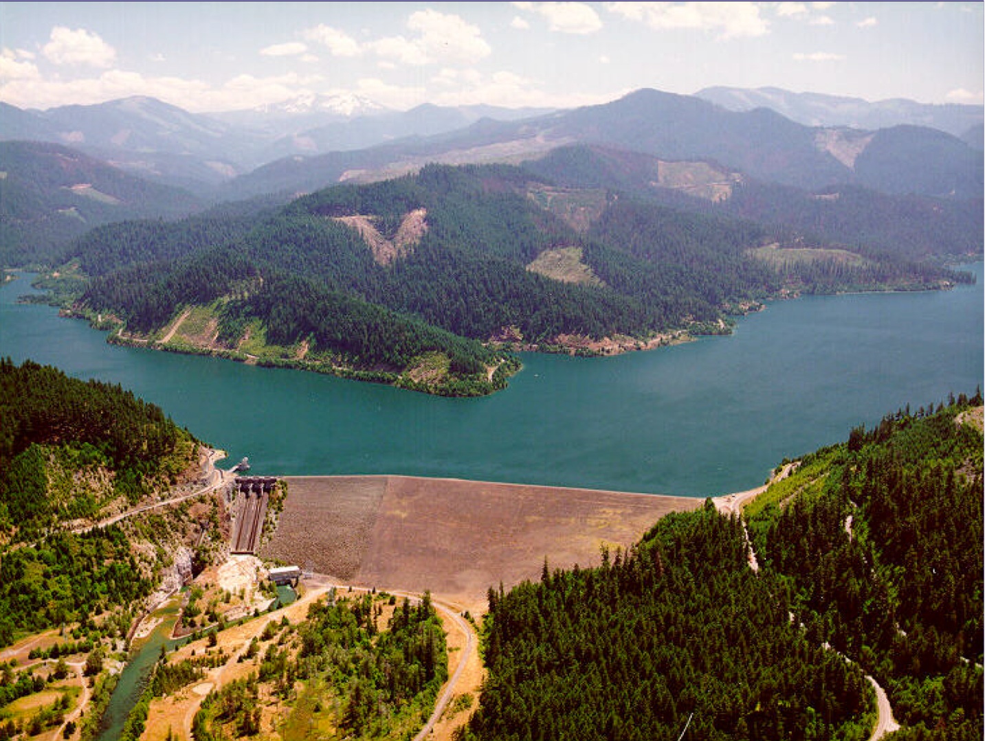
Hills Creek dam on the Middle Fork Willamette River, upstream of Oak Ridge, Oregon
(photo: Army Corps of Engineers)
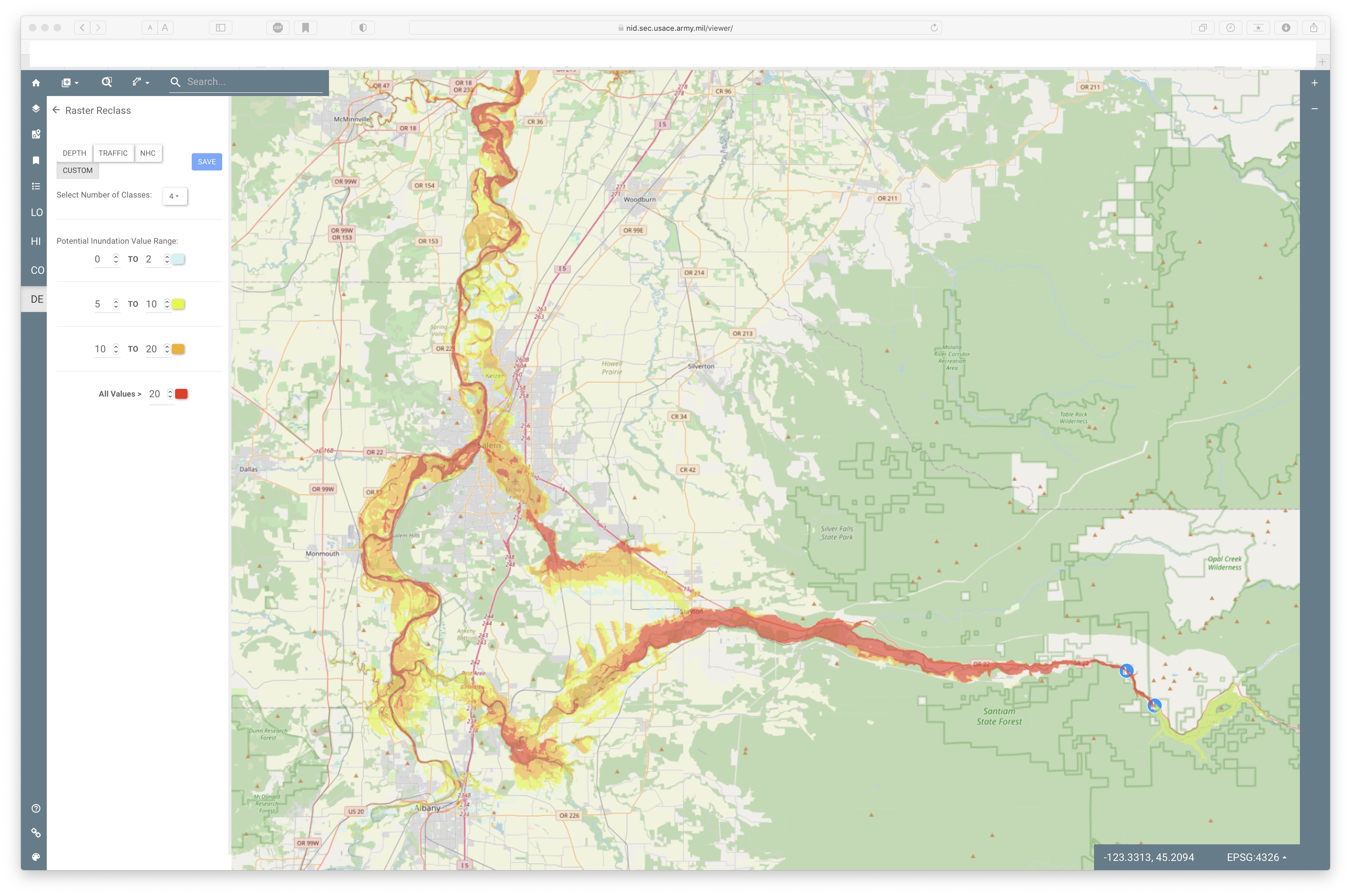
The US Army Corps of Engineers, which runs most of the large dams in the Cascades uphill of the Willamette valley, has - finally - released inundation maps that shows potential threats to downstream communities. These maps are customizable on their website to show potential impacts from a variety of scenarios - individual dams, breach at maximum or minimum pool levels, etc. They are also customizable to show different colors for different depths.
 Fortunately, the likelihood of this happening is small but the consequences would be beyond catastrophic. It is good that the subduction earthquake in northern Japan on March 11, 2011 only broke one of that region's dams (and it was a small one). Hopefully the Cascades dams are far enough inland that the shaking they will experience won't be as severe as the projected shaking on the coast. Fern Ridge is the only big dam west of I-5 and would shake more than Lookout Point, Cougar, Detroit, Hills Creek, etc. While Fern Ridge reservoir has a large surface area it is not very deep and the inundation map suggests it would not have much impact outside the Long Tom river floodplain.
The other, perhaps more likely, scenario for dam failure(s) is a large atmospheric river that would melt high snowfall in the mountains surrounding the dams.
A certain scenario that gets almost no public mention is the impending "low flow shutdown" of the Alaska pipeline, which powers the motors of Cascadia - including food delivery trucks. It is popular in some circles to call for the end of fossil fuels, and that is a worthy goal, but those calls
never mention we are totally dependent on concentrated energy to power literally everything in our civilization and we have made almost no practical efforts to restructure society to use less energy (renewable or not). We are entering the decline and fall of fossil fuels, whether we want it or not, whether prepared or not. Maintaining dams and other critical infrastructure is very energy intensive. Rebuilding after a dam failure, large earthquakes, etc. would require access to abundant energy, minerals, other materials. Long(er) term thinking is required.
"in 1987 the Oregon Emergency
Management Division estimated that a completely catastrophic failure
of the Hills Creek Dam, an extremely unlikely event, could require the evacuation
of over 250,000 people with damages in excess of $10 billion. Adjusting
these 1987 estimates for inflation and for population growth suggests that damages
could easily exceed $20 billion. Detailed casualty estimates have not been made
for catastrophic dam failures affecting Lane County. However, given
the large inundation areas, high water depths, and the logistical difficulties
in evacuating 250,000 people to safe ground, it is not difficult to imagine
that a truly catastrophic dam failure could potentially result in 1,000 or more
deaths. "
-- City of Eugene, "Multi-Hazard Mitigation Plan"
https://docs.google.com/document/d/1cUO27IJv_cb4I5wLtBbtG30eNdHILss5/edit
Dam Safety Risk and Flood Inundation Mapping for Eugene/Springfield Presentation
Presented by the U.S. Army Corps of Engineers (USACE)
November 14, 2022; 7:00 – 8:30 p.m.
www.youtube.com/watch?v=hJOccp1iuGw&t=2626s
River Road Community Organization
Nov 15, 2022
Dam safety and inundation maps: In late 2021, the USACE published publicly available inundation maps in the online National Inventory of Dams (NID) that show that flooding resulting from authorized dam operations and from dam breach could cause major flooding in the Eugene/Springfield area.
The purpose of this November 14th presentation is to inform the community, understand how to read the maps, and to start an ongoing dialogue on this important topic. It is expected that this presentation is one of many discussions that we will have in the future on related topics, such as - emergency alert systems or plans for rescue and evacuation.
The River Road Community Organization (RRCO) and the Ready NW Eugene Neighborhood Emergency Preparedness Team* are co-sponsoring a presentation by the U.S. Army Corps of Engineers (USACE) on dam safety risk and flood inundation mapping for USACE dams in the greater Eugene/Springfield, Oregon area.
All are welcome to attend this presentation on November 14, 2022 at 7:00 p.m. at the zoom address posted above.
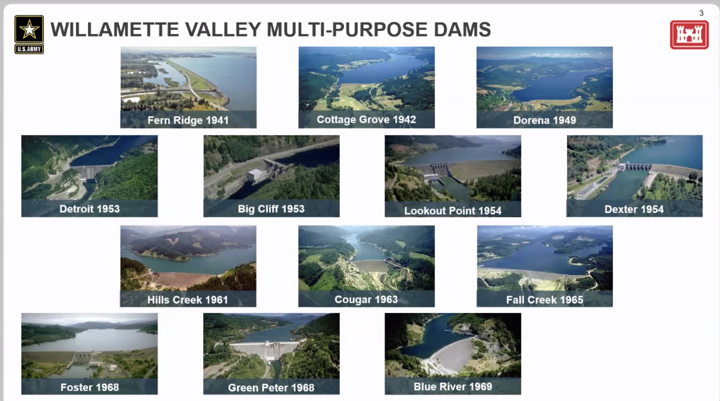
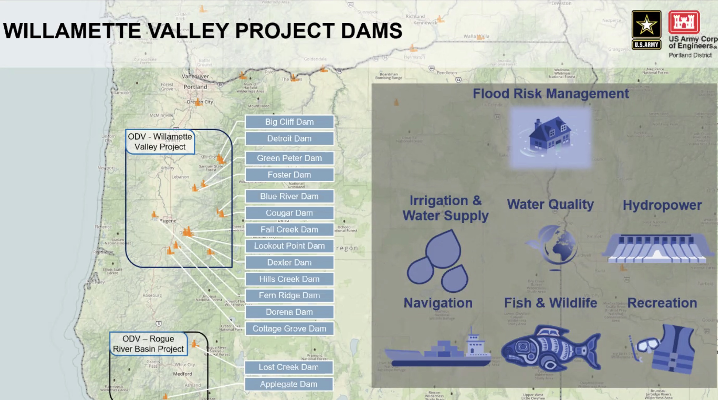
This presentation focuses on the dam safety in the Willamette Valley and flood inundation in the Eugene/Springfield area resulting from a variety of scenarios related to dam operations. The nearby nine dams which are owned, operated, and maintained by the U.S. Army Corps of Engineers (USACE) are: Fern Ridge Dam, Cougar Dam, Blue River Dam, Hills Creek Dam, Cottage Grove Dam, Dorena Dam, Dexter Dam, Lookout Point Dam, and Fall Creek Dam.
The purpose of the presentation is to inform the community and to start a dialogue on this important topic. It is expected that this presentation is one of many presentations and discussions we will have in the future. We appreciate the help and collaboration of the USACE in starting us out in this process.
Flood Inundation Mapping
In late 2021, the USACE published publicly available inundation maps in the online National Inventory of Dams (NID) that show that flooding resulting from authorized dam operations and from dam breach could cause major flooding in the Eugene/Springfield area. https://nid.sec.usace.army.mil/#/
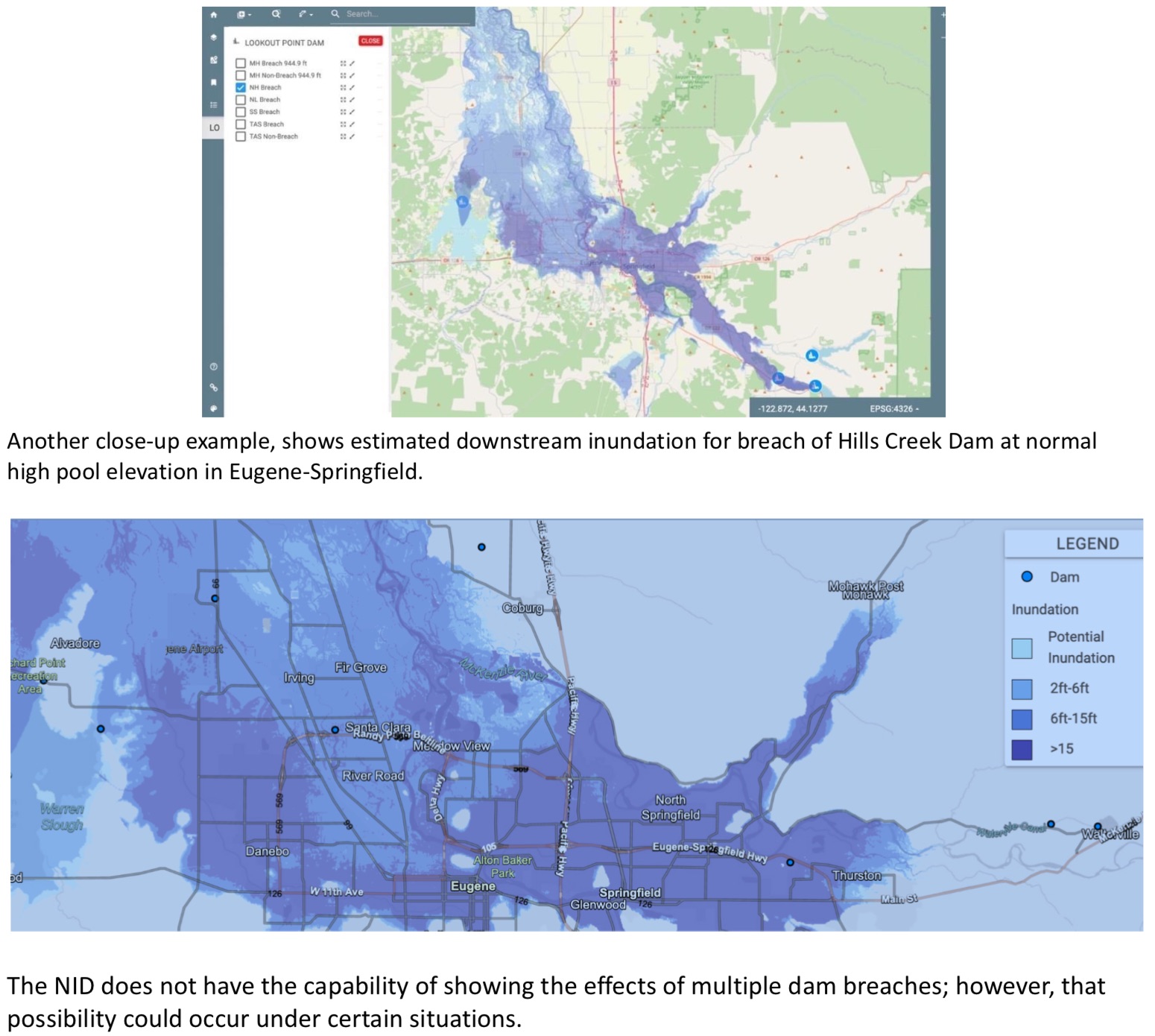
One example, below, shows estimated downstream inundation for breach of Lookout Point Dam at normal high pool elevation.
Risk Potential of Dam Breaches
In the National Inventory of Dams (https://nid.sec.usace.army.mil/#/), these nine USACE owned dams in the Eugene/Springfield area are considered High Hazard Potential dams, meaning that there is the potential for loss of life in the event of a dam breach..
For Lookout Point Dam: "The risk is driven by the high population downstream of the dam combined with two possible, but very unlikely events: 1) an extreme earthquake occurring at the same time reservoir elevations are the highest or 2) an extreme flood event that fills the reservoir at a rate faster than the dam can pass water through the spillway." [From the risk analysis of the Lookout Point Dam. https://nid.sec.usace.army.mil/#/dams/system/550098/risk]
All of these dams were built in the 1950s and 1960s prior to our understanding of risk posed by the Cascadia Subduction Zone. According to an USACE representative, dams have historically performed well during earthquakes. However, there is always potential for damage or breach due to a large earthquake event.
According to the Oregon Office of Emergency Management, "Currently, scientists are predicting that there is about a 37 percent chance that a megathrust earthquake of 7.1+ magnitude in this fault zone will occur in the next 50 years." https://www.oregon.gov/OEM/hazardsprep/Pages/Cascadia-Subduction-Zone.aspx
CONTENT OF THE PRESENTATION AND DISCUSSION:
Given that most of Eugene would be dramatically affected in the event of a dam breach and subsequent flooding, we want to inform the community and discuss the following questions in this presentation:
-
What is the hazard potential of dam failure of each of the nine USACE dams near Eugene?
-
What is the structural condition for each of these nine dams, i.e., how well would each of the dams withstand a 7.0+ earthquake; extreme flooding event?
-
What factors would lead to a breach of a dam, e.g., earthquake 7.0+; extreme flooding event?
-
What steps are being taken by USACE and others to reduce these risks and increase the structural integrity of the dams?
-
Given the increase of extreme weather events and effects of increased runoff from recent wildfires, is the USACE concerned about how these changes might affect the dams?
-
What is the estimated water elevation above sea level if both the Hills Creek Dam and Lookout Point Dam were to breach at normal capacity?
[Note: In 2014 when there were public discussions about potential dam breaches, some folks remember being told that the water level could get as high as 450' above sea level where Willamette Street intersects with I-5. Most of the houses in the lower elevations of Eugene/Springfield are well under 450' above sea level. To find out the sea level elevation of a specific property, go to: https://en-us.topographic-map.com/maps/nfa/Eugene/]
-
How will the public be alerted in the event of a dam breach? Who will issue these alerts? What amount of notice will residents receive? What will residents be instructed to do to protect themselves? Is the 2019 "A Guide to Public Alerts and Warnings for Dam and Levee Emergencies" still in effect?
-
How long in hours will it take from the time of the breach for Eugene/Springfield to experience various levels of flooding? How can we access this data in the National Inventory of Dams (NID) database?
-
What can Eugene/Springfield residents do ahead of time to prepare for the potential of a dam breach?
-
What realistic safety/evacuation options exist for residents in such an event to help ensure our safe evacuation, successful shelter in place, or rescue.
DESIRED OUTCOMES OF THE PRESENTATION AND DISCUSSION:
-
Identify who the major players are in the event of a dam breach flooding event (e.g., USACE, Lane County Emergency…) and establish ongoing communication links;
-
Reach out to and communicate with the public;
-
Identify community volunteers who will collaborate to develop and implement a local emergency preparedness plan for our neighborhoods;
-
Conduct follow-up meetings, presentations and training exercises to further build our understanding of this type of emergency and what can be done to mitigate the risks.
-
Communicate with decision makers (e.g., elected representatives, government representatives) to ensure that steps are being taken to reduce risk.
-
Strengthen the public dialogue on emergency preparedness concerns regarding this and other issues.
* * *
We will allow time for questions and answers after the presentation. The meeting will be recorded and posted for later viewing.
We want your questions ahead of the presentation! Please email questions you would like the USACE presenters to answer to ReadyNWEugene@gmail.com.
Thank you. See you at the zoom meeting on November 14th!
_____________
* The Ready NW Eugene Neighborhood Emergency Preparedness Team comprised of representatives of the River Road Community Organization, Active Bethel Community and Santa Clara Community Organization.
______________
This briefing paper was prepared by Charlsey Cartwright with edits by Matthew Chase, P.E., USACE Portland District Dam & Levee Safety Section, Dam Safety Program Manager
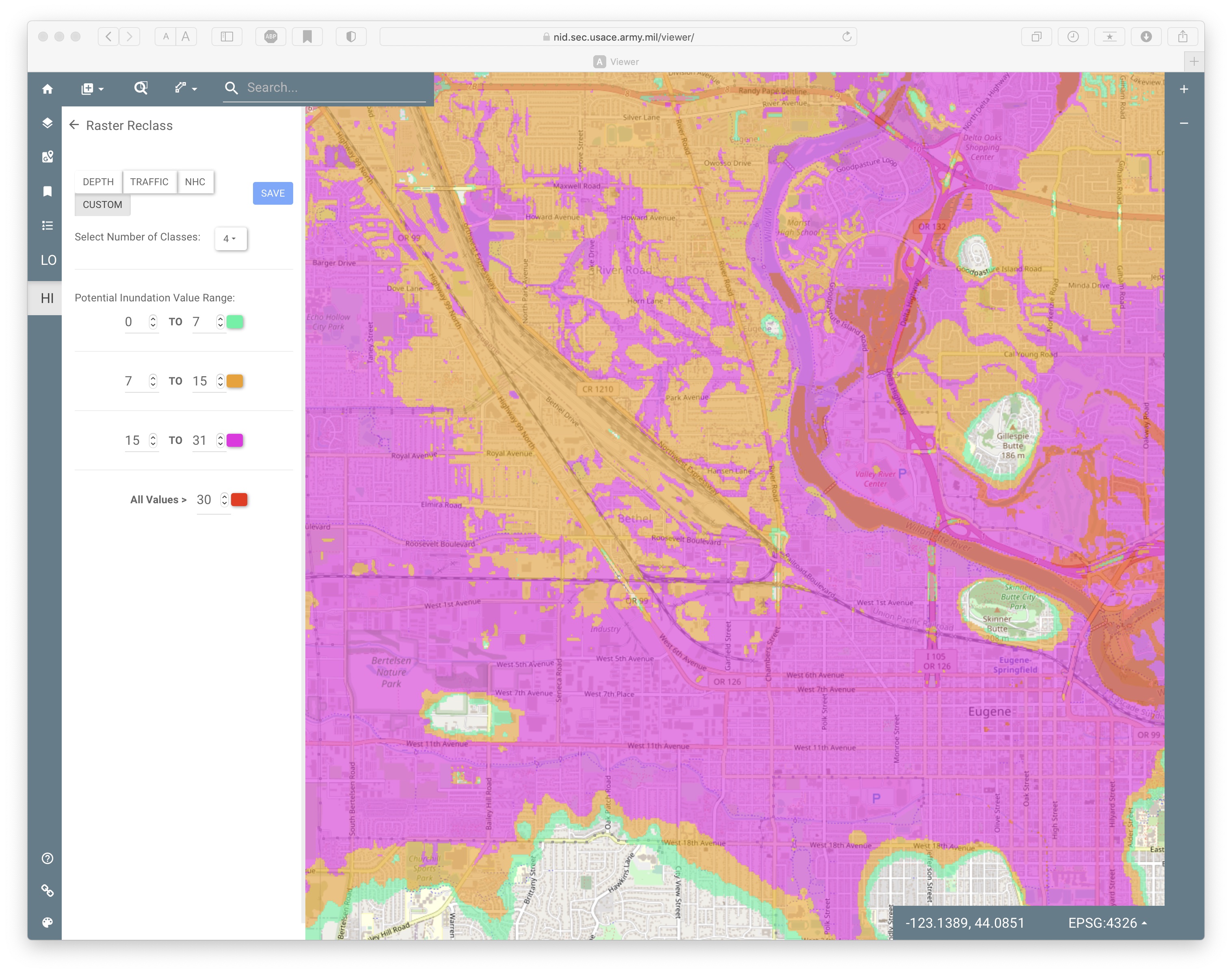
Lookout Point: default colors show impact of tsunami like wave that would be unleashed. The use of different shades of blues makes the full depths difficult to determine. The map also defaults to 15 feet as the maximum depth which is less than half the height on inundation would be in parts of the metro area - notably central Springfield and Glenwood. Keep scrolling down to see how these maps can be modified for increased clarity.
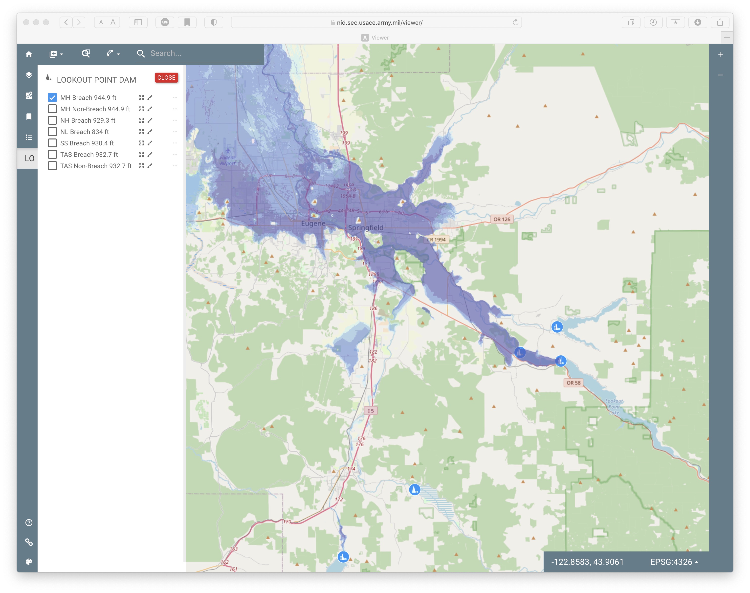
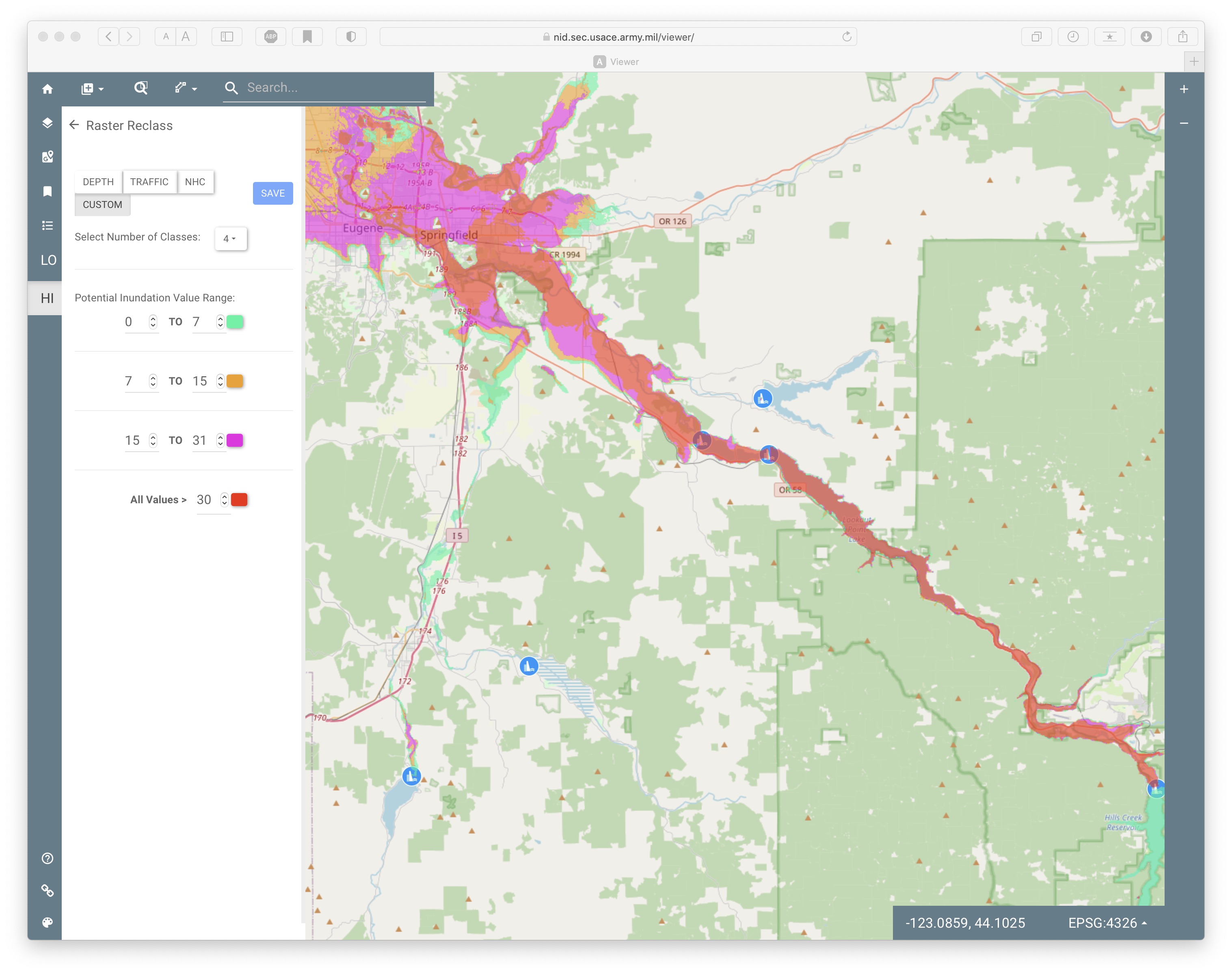
clicking on the brush logo next to the scenario option (Maximum Height Breach, 944.9 ft above sea level in the above graphic) selects options for customizing colors and depth of inundation. Making the colors more distinct better highlights the range of inundations.
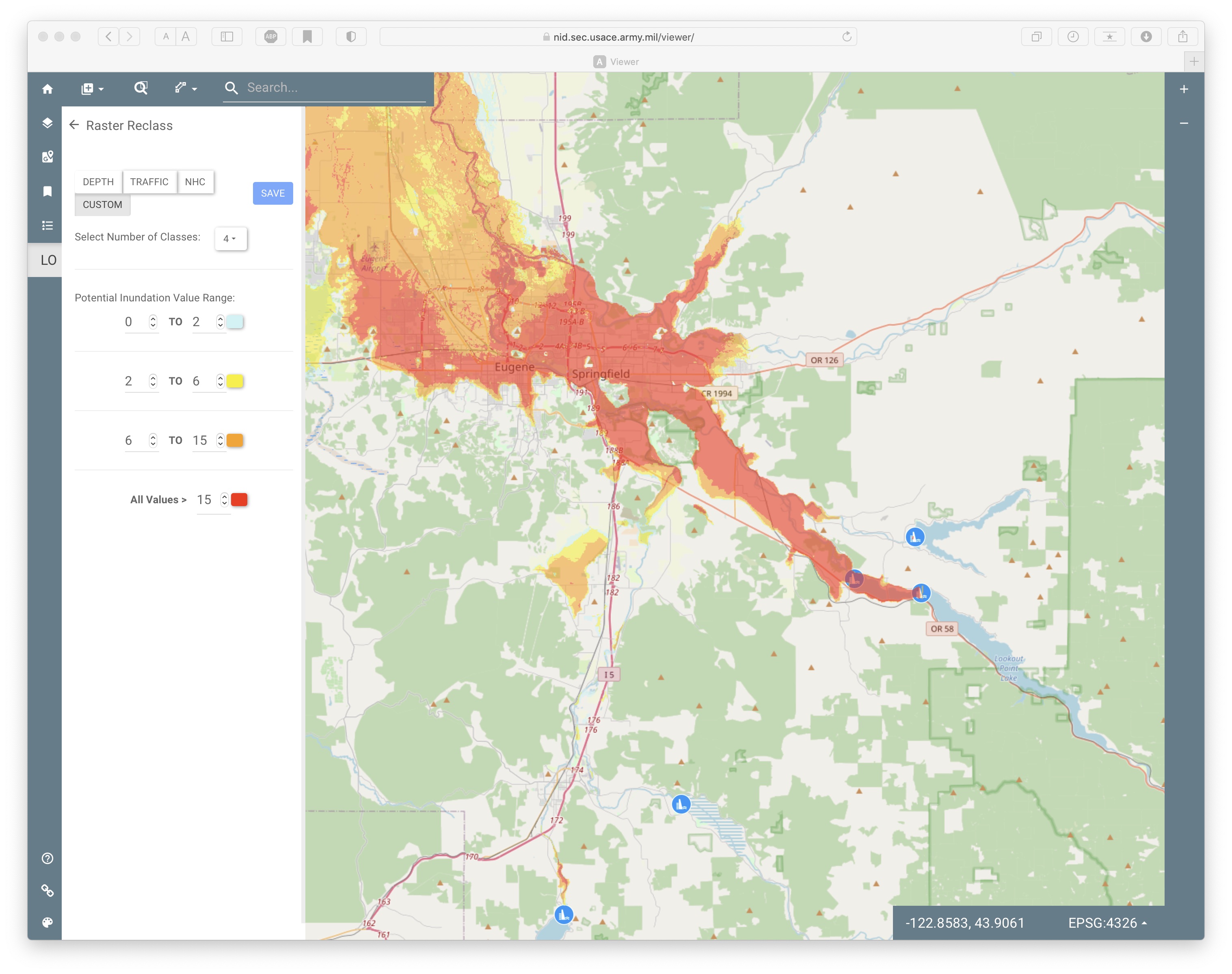
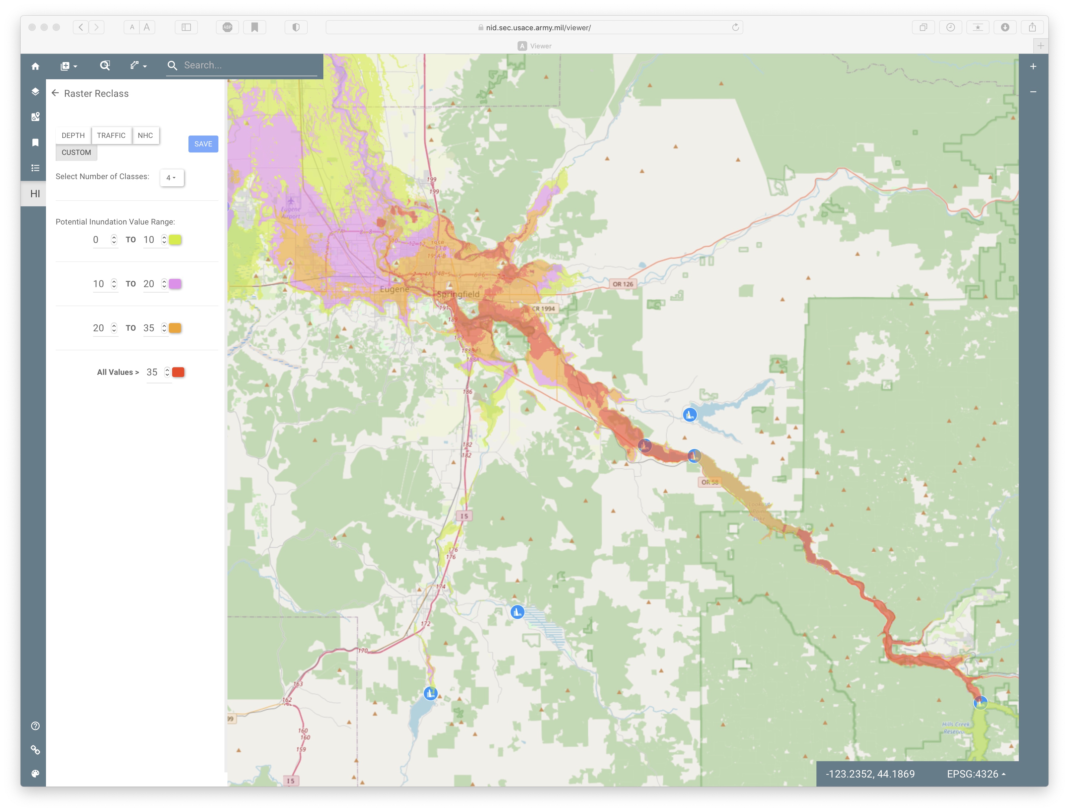
Customization also allows selction of different inundation levels. A couple dam breaches could have floods substantially higher than the default of 15 feet. Additionally, the flood waters would not just be high water levels, they would carry tons of debris similar to tsunami tearing through coastal towns that could cause injuries and property damage. Changing the potential inundation values can show the potential risks to particular locations or highlight that a couple of the dams have much more potential damage - Lookout Point, Hills Creek, Cougar, Fall Creek, Detroit.
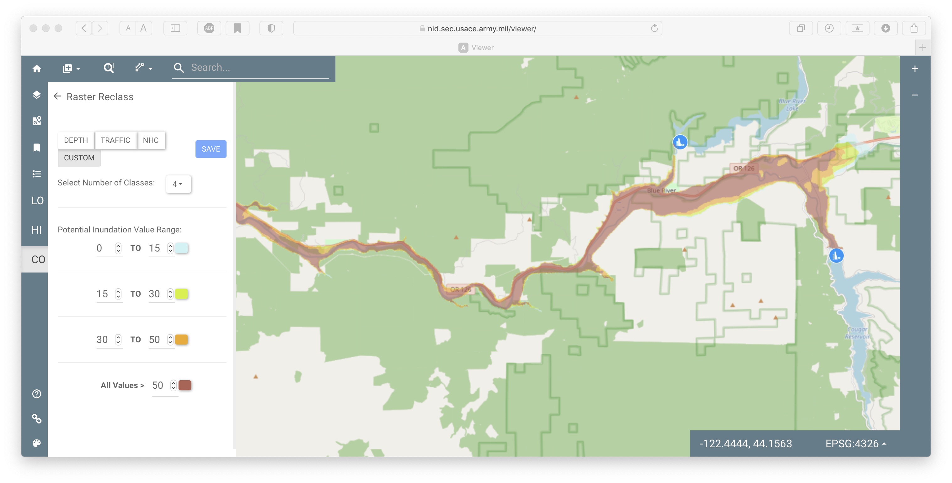
In contrast, Fern Ridge, the lone Army Corps dam in the Willamette Valley that is west of I-5 (and closer to the subduction zone, therefore more likely to experience stronger shaking), would not have much flooding outside the immediate zone of Long Tom river. Fern Ridge reservoir is large in surface area but it is not deep.
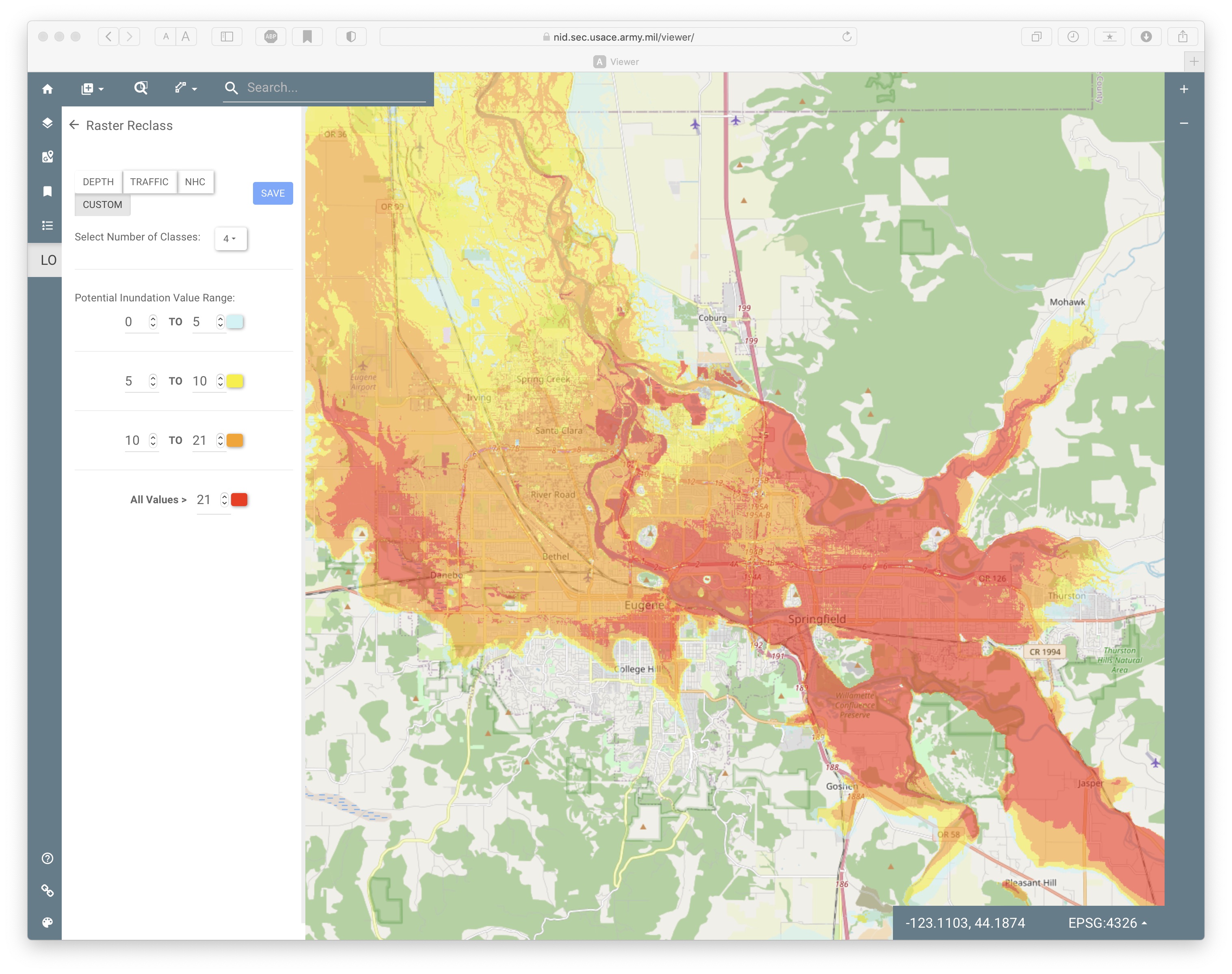
and Hills Creek with the customization increased to over 35 foot inundation - parts of Springfield would still be flooded greater than this:
Hills Creek (upstream of Oakridge): red highlights more than 30 foot depth
Hills Creek: close up of potential impact to Eugene. White shows various high points that would escape inundation. Note that the overpasses on Beltline, Delta, 105 would still be in the flood zone.
Cougar dam: red indicates over 50 foot depth
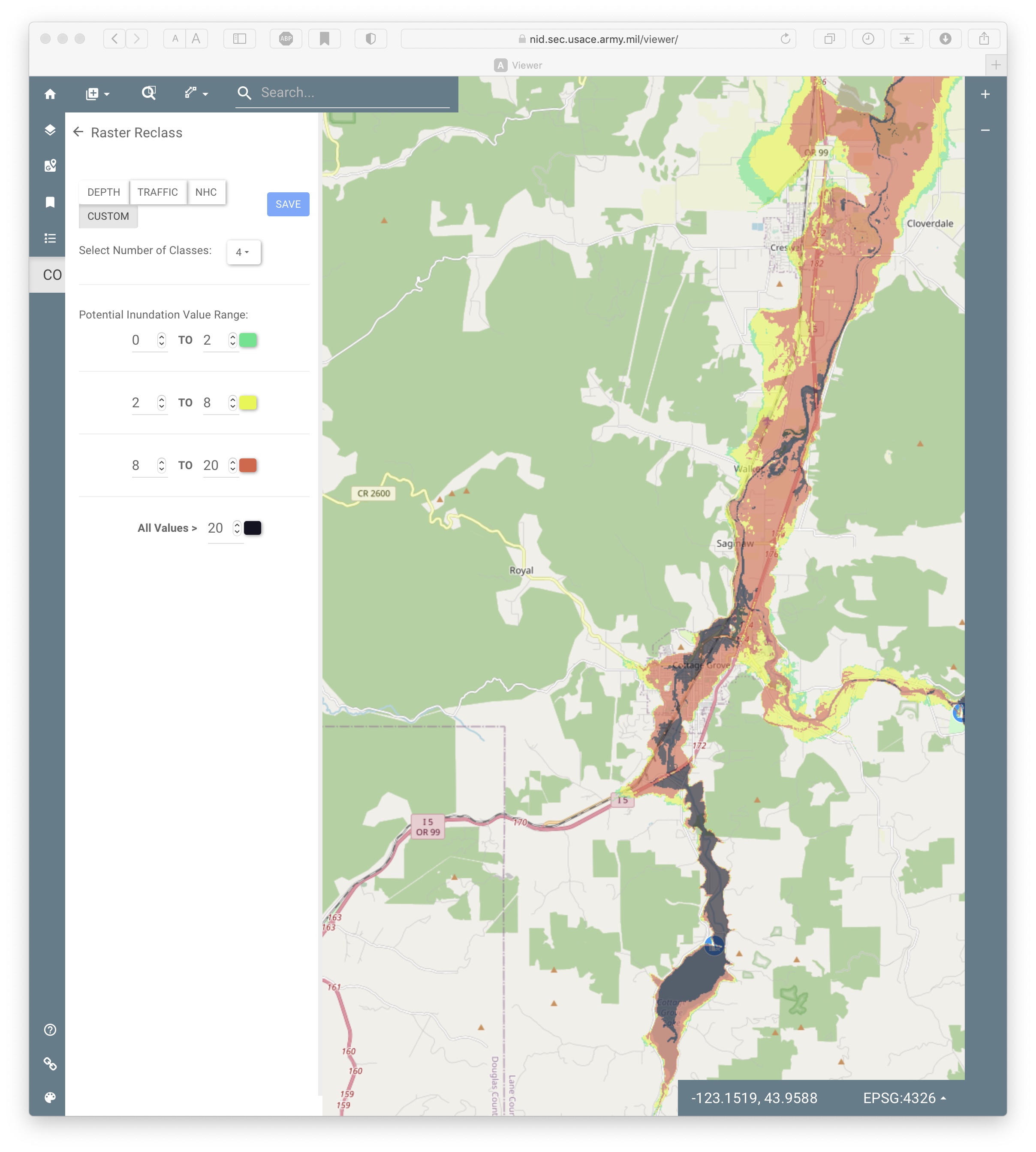
Cottage Grove dam: would flood downtown Cottage Grove (the reason the dam was built was to address historic flooding there)
Detroit dam: parts of Salem would flood over 10 feet (orange), red indicates over 20 foot depth
a very small sampling of dam danger risks, especially as facilities age and the resources for repair get constricted
weather.com/news/news/2019-11-10-associated-press-aging-dams-risk-united-states
Aging Dams in U.S. Expose Thousands to Risk
An investigation identified 1,688 high-hazard dams in unsatisfactory or poor condition.
Georgia led the nation with nearly 200 high-hazard dams in unsatisfactory or poor condition.
Safety officials estimate it would take more than $70 billion to repair and modernize the nation's 90,000 dams.
http://oilbeseeingyou.blogspot.com/2007/07/post-peak-dam-maintenance-or-lack.html
Tuesday, July 31, 2007
Post Peak Dam Maintenance, or Lack Thereof
"Dam failures are of particular concern because the failure of a large dam has the potential to cause more death and destruction than the failure of any other man-made structure. This is because of the destructive power of the flood wave that would be released by the sudden collapse of a large dam."[2] What will be the fate of the world's large dams after peak oil as energy declines, technology falters and budgets for inspection and maintenance of these critical and dangerous facilities begin to be pared back in deference to perceived more immediate societal priorities?
JUNE 1999:
ONE OF CENTRAL OREGON'S DAMS COULD COLLAPSE IN A MODERATE EARTHQUAKE, prompting federal officials to warn people immediately below Wickiup Reservoir to flee to higher ground at the first sign of ground movement. "If people can feel an earthquake in the area, it's probably going to be strong enough to do something to the dam," said Larry Wolf, dam safety expert with the U.S. Bureau of Reclamation in Boise.
It is the first time in the Northwest that the bureau has advised residents to evacuate as standard practice during an earthquake. "Certainly we don't want to create panic, but we want people to be aware," he said. The dam is about 20 miles [32 kilometers] south of Bend and much closer to a number of upscale developments, including Sunriver, which can be packed with 20,000 people on a summer day.
The bureau estimates that floodwaters could endanger roughly 10,000 people. However, Wolf said there would be time for most people to evacuate. The flooded area would roughly follow the channel of the Deschutes River, extending beyond the banks for more than a mile in some places, he said. Because the river channel flattens in some developed areas, floodwaters would take about 14 hours to reach Bend, he said. An earthquake with a magnitude of 5.0 on the Richter scale could cause a catastrophic failure of the 2-mile-long earthen dam. However, he said the chances of such an earthquake are estimated to be about one-tenth of 1 percent each year. Wolf characterized the risk as remote but real. P The Klamath Falls earthquakes in 1993 were pegged at magnitudes of 5.6 and 6.0, and the Scotts Mills earthquake earlier that year in the Willamette Valley hit 5.6.
Wolf said data collected at the dam in recent years indicated that the saturated silt and ash layers of earth beneath the dam could liquefy during an earthquake. The dam was completed in 1949 and holds up to 200,000 acre feet of water, or enough water to cover 200,000 acres to a depth of one foot. The water is used primarily for irrigation in Jefferson County. Wolf said reclamation engineers have suspected for years that Wickiup Dam was at risk. Those fears were confirmed with additional analysis and testing last year. In February, the bureau decided it needed to warn local authorities and the public about the situation and to undertake a $40 million renovation project.
Jim Mumford, who heads the bureau's dam safety division in Boise, said these are far more specific warnings than the bureau has ever issued to Pacific Northwest communities. For example, when the Ochoco Dam near Prineville was at some risk of failing several years ago, the bureau told residents to contact local emergency service officials if there was a problem with the dam. But with Wickiup, he said, there won't be time to await instructions from officials. "This is the first time where we're saying, 'Don't wait for notification. The earthquake is the notification,' " he said. The bureau also has designated escape routes, then posted fliers and sent brochures to area homeowners with maps of those routes. Larry Zakrajsek, who does risk analysis for the bureau, said the agency did not rush to warn people partly because the danger is small and the dam has functioned well for 50 years.
By Gordon Gregory, Correspondent, The Oregonian The Spring Break Quake of 1993, which rattled buildings across western Oregon and caused $30 million in damage, was a harbinger of an 8 or 9 magnitude quake that is in Oregon's future, geologist Donald Hull tells legislators. "It's been 299 years since the last such event," Hull said. "The window of vulnerability is open again." Hull, who is Oregon's chief state geologist, hopes the Legislature will set aside money for better mapping of earthquake hazard zones and for public safety campaigns to let people know what to do when the Big One hits.
The department has been able to retrofit about 60 bridges since the Spring Break quake, but ODOT estimates that at least 1,500 other bridges in western Oregon are in need of at least some earthquake strengthening. Frank Nelson, ODOT's bridge preservation engineer, said eight more bridge projects are planned, and that the department might be able to do an additional four if lawmakers approve a gas tax increase for road repairs. Those projects should at least be enough to keep Interstate 5 -- Oregon's main north-south lifeline -- open in the event of a major earthquake, Nelson said.
Scientific evidence shows that major offshore earthquakes occur off Oregon's coast once every 350 to 500 years. The last one, in 1700, drowned coastal forests and sent tsunami waves across the Pacific so powerful that they destroyed Japanese fishing villages. Such a quake would not only devastate Oregon coastal communities, but inland areas as well. "The Willamette Valley is a big trough full of loose soils, gravel, sands and silts," he said. "When earthquake waves travel through that kind of sediment, they get bigger; they amplify. I'm just praying it won't happen in my lifetime."
Senate President Brady Adams said lawmakers are aware that Oregon is due for another huge earthquake. "It's hard to define in a specific time frame what the risk is. Is it going to happen tomorrow, or 200 years from now?" the Grants Pass Republican said. "There's no question the threat of earthquakes is real, but we also know we have school funding and other needs that are before us today."
Hull said he can't argue with that logic, but still thinks the Legislature should consider increasing at least to a small degree its financial commitment to preparing the state for the Big One. "There's nothing else in our foreseeable future that's going to be as devastating," the state geologist said. "It's not going to do us any good to fund education programs if the school buildings end up falling on kids' heads."
www.csmonitor.com/2007/0913/p02s01-usgn.html
PROBLEM DAMS ON THE RISE IN US
Pennsylvania has seen a fivefold increase in deficient dams since 1999.
By Mark Clayton | Staff writer of The Christian Science Monitor
from the September 13, 2007 edition
The Kaloko dam in Hawaii stood 116 years – until last year when it collapsed after heavy rains, killing seven.
Potential disaster was averted in April in Hollis, N.H., when a dozen families were evacuated and engineers made a controlled breach of an old pond dam to keep it from failing .
Such incidents are warning signs that many of the nation's more than 87,000 dams are in need of repair. Last month's high-profile collapse of the I-35 bridge in Minneapolis focused America's attention on bridge problems. The nation's dams are worse off.
In 2005, the last time the American Society of Civil Engineers rated America's infrastructure, bridges received a "C" grade; dams earned a "D."
Even that rating may be generous, a Monitor analysis of dam-inspection data shows. Since 1999, the number of "high-hazard" dams rated "deficient" has more than doubled, according to data from the Association of State Dam Safety Officials (ASDSO) in Lexington, Ky. High-hazard dams are those whose failures could cause fatalities. In 1999, the US had 546 such dams rated deficient. By last year, it had 1,333.
A second category of "significant-hazard" dams (so-called because they threaten substantial property loss) saw a rise from 339 to 949 deficient dams over the same period. In all, 2.6 percent of the nation's dams are deficient, according to the ASDSO.
"The growth of deficient high-hazard dams in this country is a major issue," says Brad Larossi, legislative chairman for the ASDSO, which represents dam-safety inspectors in all states. "The trend is rising at such a steep slope, much faster than states can do [dam] rehabilitation. Without question the overall trends are clear."
Several factors are behind the rise. Old dams continue to deteriorate or may fail suddenly because of inadequate spillways and trees growing on dams. Many states don't have enough dam engineers to keep up proper maintenance, causing the repair backlog to grow. And as more homes and businesses are built closer to dams, the hazards increase, a phenomenon dam-safety experts call "hazard creep."
Some experts claim that some of the rise is due to better reporting, an encouraging sign. "To be frank, there's been in the past a reluctance in some quarters to identify too many dams as deficient," says Mark Ogden, administrator for dam-safety engineering at the Ohio Department of Natural Resources in Columbus. "But there's also been a strong effort by our association to increase awareness of this problem. We all are realizing we need an honest assessment."
Some states are seeing a faster rise in deficient dams than others. Pennsylvania leads the pack with 215 deficient high-hazard dams, 172 more than in 1999. Not far behind is Ohio, with an increase of 158 . Other states, such as Colorado, New Jersey, and California have seen declines. Some of that is due to better funding, experts say. All three have boosted dam budgets by a third or more since 1999.
Those increases are in contrast to federal dam spending. The nation's dam-safety program, which helps fund safety inspector and engineer training, has not been fully funded in at least five years, Mr. Larossi says. Actual funding is about $5.9 million, well below the $9 million budgeted, he says.
As a result, the number of full-time inspectors has not increased since 1997 (excluding Florida, which claims to have hired 45 inspectors). That leaves each inspector responsible for about 195 dams on average; the ASDSO recommends no more than 50.
"We have seen increased awareness over the importance of adequate funding for state inspectors, but these offices are still understaffed," says Stephanie Lindloff, of American Rivers, an environmental group.
The enormous US dam problem no one is talking about
By Gaylord Shaw
Christian Science Monitor
January 3, 2006
DUNCAN, OKLA. - The landscape of America, at last count, is dotted with 79,272 large dams. Most of them safely deliver bountiful benefits - trillions of gallons of water for drinking, irrigation, and industrial use, plus flood control, recreation, hydroelectric power, and navigation.
That's the good news.
Here, in my opinion, is the bad news: Disaster lurks in thousands of those dams.
At least 3,500 of America's big dams are unsafe, according to inspection reports filed away in obscure nooks and crannies of government offices across the country. Thousands more dams also are unsafe, the American Society of Civil Engineers concluded this year, but no one knows for certain how many because few states have the funds for even cursory safety inspections.
Thus, every moment of every day, unsafe dams form a vast reservoir of danger throughout America. That's not an overstatement. I'm not a professional engineer, but I've spent nearly two-thirds of my 45-year career in journalism studying unsafe dams. I've done on-the-scene reporting on dam failures that killed 175 people and caused billions of dollars in property damage. I've interviewed scores of victims, dozens of state and federal engineers, inspectors, and officials, and examined records on hundreds of dams.
In my view, the cumulative hazard posed by unsafe dams is huge, but it remains largely unexplored by the media. When a dam fails - and records suggest dozens do each year - the events usually are viewed as local, transitory incidents rather than a symbol of a national problem.
Hurricane Katrina underscored the peril of depending on man-made structures for protection against disaster. Failure of the New Orleans' levee system during the storm this year contributed to prolonged flooding and 1,300 deaths.
Months later, as scenes of misery and dislocation lingered in the public mind, President Bush urgently asked Congress to approve $3 billion for the Army Corps of Engineers to begin rebuilding New Orleans' battered levees. The House of Representatives included that amount in a $29 billion hurricane recovery assistance package it passed three days later.
In concept and construction, levees are close cousins of dams. But while politicians flocked to support repair of New Orleans' levees, they've virtually ignored a proposed Dam Rehabilitation and Repair Act which has languished for nearly a year in a House subcommittee. The proposal would authorize the Federal Emergency Management Agency (FEMA) to disperse $350 million over four years to help states repair unsafe dams. Chances of Congress enacting such a repair program anytime soon are slim.
The $350 million program would be a down payment of less than 10 percent toward the estimated $36.2 billion total cost of repairing America's unsafe dams. It also is approximately one-eighth of the amount the president is seeking for repair of the New Orleans' levees.
This is not to suggest that the New Orleans' levees go unrepaired. But from New England to Hawaii more and more aging dams are experiencing problems, with little public awareness. A few large and small examples:• Taunton, Mass., got national attention in October when a 173-year-old, 12-foot-tall wooden dam above its business district began to buckle. Stores and schools were closed for a week and townspeople headed for higher ground. The crisis eased when the water level behind the dam was lowered. The federal government is now paying 75 percent of the $189,410 cost of tearing down Whittenton Mills Dam and replacing it with a new one.
• In the placid Schoharie River Valley of upstate New York, a volunteer group calling itself Dam Concerned Citizens was formed last month to press for emergency repairs to 182-foot-tall Gilboa Dam, built 80 years ago to supply drinking water to New York City. The dam has been leaking for years. Now citizens have established their own website which distributes emergency notification plans and publicizes preselected evacuation routes for use should the dam fail (www.gilboadaminfo.com).
• Residents of Denver, Colo., population 2 million plus, were warned last month by the Corps of Engineers that serious safety problems have been detected at Cherry Creek Dam, a 141-foot-tall earthen structure. The dam was built 55 years ago on what was then windswept pastureland 10 miles south of Denver. Now the dam looms above Interstate 225, a cluster of office parks and swank homes, a nationally known golf course, and several schools.Bruce Tschantz, professor emeritus at the University of Tennessee who 25 years ago helped establish the first Office of Dam Safety in the then-nascent FEMA, reached back into classical mythology to fetch a phrase - "the sword of Damocles" - to express his concern about the dangers posed by deficient dams perched above developed areas. (Damocles was a courtier at the court of Dionysius I in the 4th century BC. He was so gushing in his praise of the power and happiness of Dionysius that the tyrant, to illustrate the precariousness of rank and power, gave a banquet and had a sword suspended above the head of Damocles by a single hair.)
"We know what the problems are, we know where they are, and we know how to fix them," Dr. Tschantz said in a telephone interview. It's that next step - actually getting the money to fix them - where we're stalled."
Tschantz doesn't point fingers of blame. But it's clear to me that Congress and several presidents, including the current occupant of the White House, share culpability on the national level, and that too many state and local officials have grown weary of trying to find sources of financing to make dams safer.
Jimmy Carter was the last president to display serious and sustained interest in the issue. He had been in office less than a year when, in the early morning darkness of a Sunday in November 1977, a never-inspected dam in the mountains of his home state of Georgia collapsed and sent a wall of water crashing down upon the campus of Toccoa Falls Bible College - a campus he had visited several times.
The Kelly Barnes Dam on Toccoa Creek dated back to 1899, when a rock-and- timber structure was built across a fast-flowing mountain stream to impound water for a small hydroelectric plant. Later, Toccoa Falls Bible Institute chose the valley below as the site for its campus, took over the power plant and, in 1937, decided to construct an earthen embankment over the original dam, eventually raising the structure's height to 42 feet.
Twenty years later, in 1957, the school abandoned the power plant. For the next two decades, the dam was neglected, visited only by an occasional fisherman or hiker. Pine trees grew to maturity on its downstream slope, sending roots deep into the dam's core. Portions of the steep embankment vanished in a landslide, but there were no repairs, even though water seeped almost continuously from the base of the dam. Finally, the weakened 78-year-old dam collapsed during a rainy night in Georgia.
In the valley below, Eldon Elsberry and two friends were on patrol in the campus fire department's Jeep. When the wall of water hit, it overturned the vehicle. "One minute the water [in the creek] was inches deep, and the next I was swimming for my life," Mr. Elsberry said. "I saw the bank and made for it." He turned and saw one of his friends struggling in the water. "I reached for his hand. He went by so fast I couldn't touch him."
Experts later calculated that the water released by the dam's collapse weighed approximately the same as 7,500 locomotives. As the water crashed across the campus, it destroyed a dormitory and crushed a cluster of mobile homes where married students lived.
Later, in the mud and tangled debris, 39 bodies were found. Twenty were children. College officials said they never hired a private consulting engineer because they had no idea it had safety problems. The state of Georgia never inspected the dam because, at the time, there was no state law requiring such inspections. Few other states had dam safety laws then, either. Pennsylvania was one of the exceptions. Its tough law was spurred by memories of the 1889 collapse of South Fork Dam above Johnstown that killed 2,209 people. Yet even with the strong state law requiring regular safety inspections, another 55 people in the same community died in July 1977 after the failure of Laurel Run Dam, just a few miles from where South Fork Dam triggered the disaster 88 years earlier.
While all states except Alabama now have laws or regulations establishing dam safety programs, enforcement is spotty, largely because of the paucity of inspectors. In Texas, for example, there are only six state employees to inspect nearly 7,500 dams. One Texas official noted that with the current staff level "some dams would not be examined for three centuries."
Let's do the math. Two of my teenaged grandchildren live in Texas. If we count 30 years for each generation, that means all the dams in Texas will be inspected by the time my grandchildren's great-great-great-great-great-great-great-great-great-grandchildren ring in a new year in 2306. Reassuring, isn't it?
• Gaylord Shaw won a Pulitzer Prize for a series investigating the state of the nation's dams for the Los Angeles Times in 1978.
Kariba dam on verge of collapsing
via Kariba dam on verge of collapsing | Radio Dialogue by Sanele Njini
March 19, 2014
A hydroelectric dam bordering Zambia and Zimbabwe threatens the lives of 3.5 million people in the southern African region as it is on the verge of collapsing, local newspaper Zambia Daily Mail reported Tuesday.
The wall of Kariba Dam, one of the world's largest dams measuring 128 meters tall and 579 meters long, has developed weaknesses and may collapse if nothing is done to repair it in the next three years, the report said.
"We are told by engineers that if nothing is done in the next three years, the dam may be swept away," Felix Nkulukusa, chairperson of an intergovernmental committee mobilizing funds for the repair of the dam, was quoted as saying.
The dam, situated in the Kariba Gorge of the Zambezi River basin between Zambia and Zimbabwe, needs 250 million U.S. dollars to be repaired and the World Bank, the African Development Bank and the European Union have so far agreed in principle to fund the repair, he said.
"This is of great concern, as an unstable foundation can wash away the dam, a potential catastrophe event for 3.5 million people along the Zambezi River mainly in Mozambique and Malawi," he added.
In case of the dam swept away, the Cabora Bassa Hydro power plant in Mozambique will be submerged, which may affect 40 percent of electricity generation in the region, he said.
The dam, which controls 40 percent of the total runoff of the Zambezi River, will also have a pushback effect on Zambezi's major tributary, the Kafue River, which may result in the submersion of Lusaka Province, where the Zambian capital of Lusaka is located, he said.
Source: Xinhua
Source: http://www.zimbabwesituation.com/news/zimsit_kariba-dam-on-verge-of-collapsing/
Original: http://www.radiodialogue.com/kariba-dam-verge-collapsing/