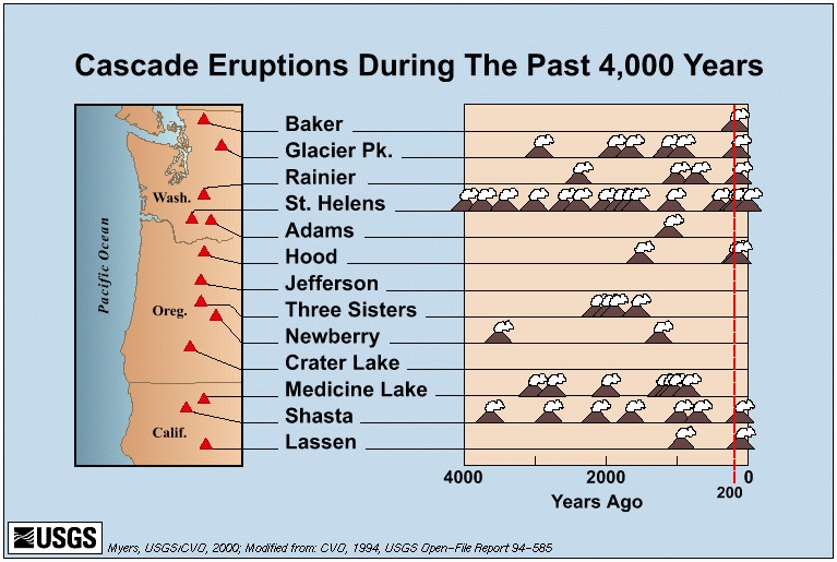
Volcanoes
could disrupt regional trade, energy supplies and food
Lane County could be economically impacted by eruptions from other major Cascade volcanos, several of which could disrupt or destroy key road and rail connections.
Three Sisters volcanoes
The City of Eugene's Multi-Hazard study suggests that the main danger from a potential volcanic eruption for Eugene would be a mud flow down the McKenzie River valley from the South Sister. Eugene and Springfield are too far away from any volcano to risk the heat of an eruption, although McKenzie Bridge and Sisters might need to be evacuated if South Sister woke up from its thousand year sleep. A wintertime eruption would probably cause severe flooding from the sudden melting of the snowpack, and a summertime eruption could cause forest fires on the scale of the 2002 “Biscuit” fire.
During the 1980 Mt. St. Helens eruption, a large lahar - an Indonesia word for volcanic mudflow - cascaded down the Toutle River, destroying structures and causing a large proportion of the total damage. While there’s probably not much that could be done to protect the communities of the McKenzie River valley from mud floods (other than evacuation), the Eugene / Springfield metro area needs to do 2 things.
It is important to ensure that there are viable contingency plans for relocating drinking water intakes from the McKenzie to the Middle Fork reservoirs (should that ever be required).
The risk of lahars also means that construction directly along the McKenzie and Middle Fork Willamette River should be prohibited. A South Sister lahar could cover the new Peace Health hospital site.
One benefit of the South Sister lahar is it might fill up the gravel pits near the Willamette / McKenzie confluence, accelerating the process of river restoration.
Spencer Butte, which looks volcanic, is the result of erosion that removed softer rocks over millions of years. The only danger it poses to the community is from people setting off fireworks during the summertime, causing a preventable forest fire. This mountain, and similar basalt buttes in the Willamette Valley floor (such as Skinner Butte and Gillespie Butte) are between 30 and 35 million years old,
(Elizabeth Orr, et al, “Geology of Oregon,” fourth edition, Kensdall / Hunt Publishing Co., 1992, p. 220)
http://vulcan.wr.usgs.gov/Glossary/Lahars/framework.html - definition of lahars
http://vulcan.wr.usgs.gov/Volcanoes/MSH/Publications/MSHPPF/MSH_past_present_future.html
www.registerguard.com/news/2003/10/26/ol.volcano.1026.html
On the rise: A fourth Sister in the making? Forces shifting landscape raise questions about future of Central Cascades, By Karen McCowan, The Register-Guard, October 26, 2003
“... His worst case scenario is an eruption generating 500 million cubic meters of lahar - flows of volcanic rock and mud triggered by pyroclastic flows of hot volcanic debris melting snow and glacier ice.
“In that case, mud flows in the the McKenzie River Valley could reach as far west as Thurston.”
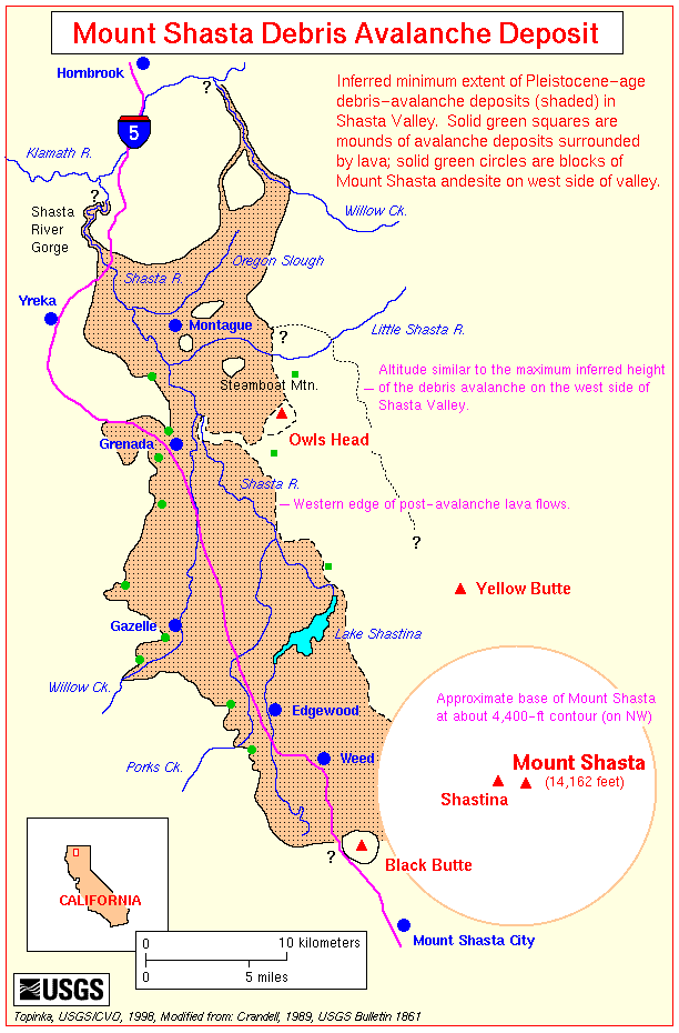
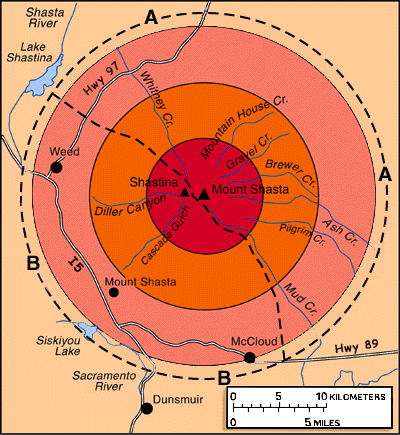
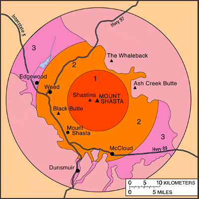
Mt. Shasta’s eruptive history includes explosive events -- a repeat would destroy I-5 along the Sacramento River canyon and the rail line. (The town of Mt. Shasta is built on pyroclastic deposits, a geological term for the hot ash from explosive eruptions.) Fortunately, any of these events would be preceded by a lengthy series of earthquakes that would enable evacuations and other preparations. An eruption of Shasta would cut off the main trade route between California and Cascadia, severing the main highway link (I-5), freight rail and even threaten the electric grid intertie that runs between eastern Oregon and northern California. Alternate routes exist for transport but they are much less direct and have less capacity.
http://www.siskiyous.edu/shasta/geo/haz.htm
About 9,500 years ago pyroclastic flows swept down from Shastina and its satellite, Black Butte, burning and burying the forests that stood where Weed and Mount Shasta City are today. Radiocarbon dating of charcoal from these forests dates the eruptions at about 9,500 years ago (Miller, 1978). The flow deposits have red (oxidized) tops and contain prismatically-jointed blocks, both of which indicate that they were emplaced at high temperatures (Figure 29). Similar pyroclastic flows from the Hotlum cone have travelled 10 to 20 kilometers down valleys on all sides of the mountain during the past several thousand years, and Miller (1980) estimates that the collapse of a dome high on Mount Shasta during a future eruption could create pyroclastic flows that would overrun low-lying areas up to 30 kilometers from the volcano (Figure 30).
Mt. Hood, the tallest volcano in Oregon, could threaten I-84 with mudflows and / or hot ashes (depending on the severity of the eruption), and would probably destroy the main drinking water source for Portland (that would have economic reverberations for the whole State of Oregon).
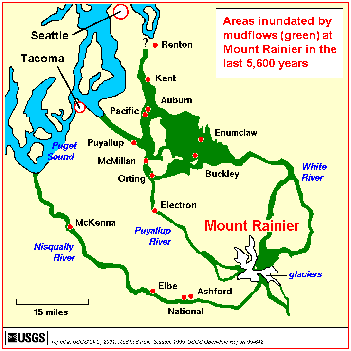
Mt. Rainier (Tahoma) poses the largest lahar risks for any Cascadian volcano, which has made extremely large mud flows in previous millennia. A number of cities downstream of the mountain would be engulfed by the lahars should a large eruption melt Rainier’s glaciers, which could sever I-5 and the main north-south rail lines for an extended period. An eruption of Rainier would sever the main road and rail routes in western Washington. It would also disrupt oil shipments to Oregon since Oregon's oil is brought in through Puget Sound docks and refineries before being sent south to Portland.
http://vulcan.wr.usgs.gov/LivingWith/VolcanicFacts/misc_volcanic_facts.html
Mount Rainier has 26 glaciers containing more than five times as much snow and ice as all the other Cascade volcanoes combined. If only a small part of this ice were melted by volcanic activity, it would yield enough water to trigger enormous lahars. Mount Rainier's potential for generating destructive mudflows is enhanced by its great height above surrounding valleys. .... Scientists estimate that debris flows can travel the distance between Mount Rainier and the Puget Sound lowland in as little as 30 minutes to a few hours. About 100,000 people now live in areas that have been buried by debris flows during the past few thousand years.